Mizdakhan Necropolis: archaeology, pilgrimage and legend in Karakalpakstan
A landscape of graves, ruins and living memory
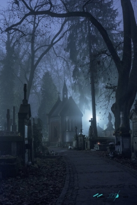
West of Khodjeyli in Uzbekistan’s Karakalpakstan region, the Mizdakhan complex occupies a striking chain of hills beside the road toward Konye-Urgench. It is not a single monument with one entrance and one story. The name refers to a broad archaeological and funerary landscape, where the remains of an old settlement sit alongside a cemetery that has continued to matter to pilgrims.
Regional and national tourism authorities describe the complex as covering roughly 200 hectares and extending across three hills. That scale helps explain why a visit feels less like entering a compact museum and more like reading a landscape. Paths connect tombs, mounds, ruined walls and later religious buildings; the open steppe and the proximity of Khodjeyli frame the site without hiding its weathered fabric.
The place is often called Mizdakhan or Mizdahkan, while the settlement’s ruins are also identified as Khodjeyli Gyaur-kala. The regional tourism authority places the complex about eight kilometres from Khodjeyli; Uzbekistan’s national tourism portal describes the necropolis as around forty minutes from Nukus. Treat the latter as a broad travel estimate rather than a guaranteed journey time, since road conditions and the exact starting point matter.
There are two stories to keep in view. Archaeology concerns the settlement and its changing material remains; pilgrimage concerns sacred graves, devotional customs and accounts carried by local communities. They overlap in the same terrain, but they are not interchangeable kinds of evidence. That distinction makes Mizdakhan more compelling, not less: visitors encounter both a long, incomplete history and a continuing religious landscape.
From an ancient Khorezm settlement to a necropolis
The settlement on the western hill is dated by the regional tourism authority to the fourth–third centuries BCE. Its location connects the site with ancient Khorezm, a historic region whose settlements developed around routes and water systems in the lower Amu Darya world. The available official overview does not provide a complete chronology of every occupation phase, so a precise, uninterrupted account should not be assumed.
Archaeological layers are described as continuing into the Kushan period, from the first to fourth centuries CE. The settlement later experienced a renewed phase between the ninth and eleventh centuries, when a fortified citadel was built. Changes in burial customs across these centuries are interpreted by the regional source as evidence of religious change, including the adoption of Islam. The ground therefore records transitions rather than one fixed culture.
The official Uzbekistan tourism account says the settlement was destroyed more than once, naming the Mongol invasion and Amir Timur’s campaign of 1338. This is a concise tourism summary, not a full archaeological report, and the available sources do not establish that every visible ruin belongs to one destruction event. It is safest to understand the site as a settlement whose fortunes shifted over many centuries before the cemetery became its most enduring public identity.
The necropolis contains burials and structures associated with different periods; the national tourism portal describes some graves as very old and places the latest burials it discusses in the fourteenth century. Named features include the underground mausoleum of Mazlumkhan Sulu, the Shamun Nabi mausoleum, the Gyaur-kala settlement, the Khalfa Yerezhep and Mademin Khan mausoleums, a caravanserai, the Kyryk-Shopan fortress and the Jomart-Kassap mound or tower. Names and transliterations vary across sources.
Architecture, devotion and stories that should remain legends
Mazlumkhan Sulu offers one of the most distinctive architectural encounters. Uzbekistan’s tourism portal describes it as a semi-subterranean monument, with a portal and dome visible above ground and the principal rooms reached by a vaulted stairway. Its central chamber has a domed roof and decorated walls. The account also records a Persian inscription fragment found in the early twentieth century, a small but tangible clue to the monument’s layered past.
The same official page presents a romantic story about a ruler’s daughter and the young man who built the underground structure to prove his love. It is explicitly a legend, not a verified biography of the people buried there. That distinction matters at a pilgrimage site, where oral traditions are part of cultural meaning even when they cannot be used as documentary evidence.
Another widely repeated tradition concerns the so-called World Clock or Apocalypse Clock. According to the story, a brick falls from a wall each year, and the end of the world will come when the final brick is gone. The national tourism portal also recounts the belief that the mound of Jomart-Kassap is linked to Gayomard and, in some interpretations, to Adam. These are religious and folkloric associations; the sources do not establish them as archaeological facts.
For a visitor, the legends explain why the complex remains a place of prayer and care as well as a historic site. People may arrange small piles of bricks or stones near the so-called clock and say prayers, according to the official tourism account. Observe quietly, do not move funerary objects or disturb worshippers, and follow local guidance. Photography should never take precedence over the dignity of an active cemetery.
Planning a visit: setting, timing and expectations
Mizdakhan lies near Khodjeyli, west of Nukus, in the Republic of Karakalpakstan. The regional tourism authority gives an approximate distance of eight kilometres from Khodjeyli, while the national portal describes a journey of about forty minutes from Nukus. Because published descriptions do not provide a dependable public-transport timetable, visitors should arrange a driver or confirm local transport before setting out rather than assume a frequent service.
As of October 2026, the official tourism pages reviewed for this article do not publish a reliable daily opening schedule, admission fee, ticket office or on-site visitor-service list for the necropolis. That absence should not be filled with a guessed timetable. Ask a local tourism office or accommodation in Nukus or Khodjeyli shortly before travelling; access arrangements may differ for archaeological areas, mausoleums and places of worship.
The landscape is exposed, and the complex covers a large area. Wear sturdy shoes, carry water and sun protection, and allow time to walk carefully between features rather than treating the site as a quick roadside stop. The surface around graves and ruins may be uneven; visitors with limited mobility should seek current local advice about the route and access before making the trip.
Mizdakhan rewards an unhurried visit because it asks for attention to both evidence and belief. Read the fortified settlement as archaeology, the mausoleums as architecture and burial places, and the World Clock and Adam traditions as stories that continue to shape pilgrimage. Keeping those layers distinct lets the site speak honestly: its complete history is not known, but its hills still hold visible traces of settlement, remembrance and devotion.