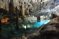
Balankanché, about six kilometres east of Chichén Itzá in Yucatán, is a limestone cave used as a ceremonial place by ancient Maya communities. Its chambers contain stalactites, constructed features, ceramics and ritual deposits that connect the underground landscape with the sacred geography of one of the region’s great cities. As of September 2026, Mexico’s National Institute of Anthropology and History, INAH, marks the site as temporarily closed. Travellers should not plan entry until INAH publishes a reopening notice.
The name is translated by INAH as “Throne of the Jaguar.” The cave became known to modern researchers in 1932, but a decisive discovery occurred on 15 September 1959 when local guide José Humberto Gómez recognised that a supposedly natural closure concealed additional chambers. Beyond it were ritual objects left in place, offering archaeologists a rare contextual record rather than a collection removed long before documentation.