Waqrapukara, Peru: the horn-shaped fortress above Acomayo
A stone silhouette above the Apurímac landscape
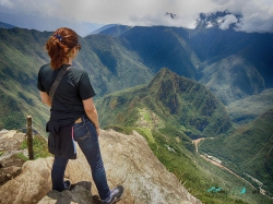
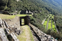
Waqrapukara does not announce itself like a city in a valley. It appears on a high sandstone outcrop in Peru’s Acomayo Province, where the rock rises above a ravine and the surrounding Andean landscape opens in several directions. The official tourism inventory places the archaeological site at about 4,300 metres above sea level and explains its Quechua name through two words: waqra, horn, and pukara, fortress. The resulting image is memorable, but the site is more than a dramatic profile: architecture, geology and approach routes all shape the experience.
The Cusco Culture Directorate records Waqrapukara as a pre-Hispanic archaeological monument classified as an archaeological landscape. Peru’s Ministry of Culture granted it National Cultural Heritage status by Vice-Ministerial Resolution 128-2017, dated July 17, 2017. That designation protects a place whose value lies not only in individual walls but in the relationship between built features, natural rock and the wide highland setting. Visitors should therefore read the whole ridgeline rather than treating the horn-like summit as a stand-alone photo point.
Its setting is physically demanding. At this elevation, a walk that appears modest on a map can feel strenuous, especially for travellers arriving directly from lower altitudes. The terrain also makes weather and visibility part of the visit: cloud can erase the long views, while rain can affect unpaved roads and exposed trails. Waqrapukara rewards patience more than speed. The most useful preparation is to allow a full day, begin with a realistic route plan and avoid assuming that a familiar Cusco excursion will have the same conditions here.
Reading the architecture without turning interpretation into fact
The official inventory describes a sandstone formation shaped by erosion, with a cone- or pyramid-like outline surrounded by eight artificial terraces and retaining walls. The stepped contour follows the natural mass rather than concealing it. From a distance the terraces help explain why the place can resemble a fortress; close up, they show how construction responded to a steep and irregular site. The name “horn fortress” is a useful guide to the silhouette, not proof that every visible space served a military purpose.
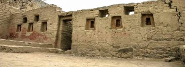
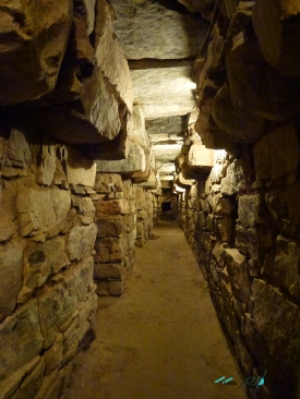
At the northern end, the inventory records two rectangular enclosures with niches and doorways featuring double or triple jambs. It interprets these spaces as associated with high-ranking Andean rituals and notes their orientation toward the south and east. Other compounds occupy the southern sector, including rooms with unusual plans, wall niches and structures fitted against the exposed rock. These details are worth noticing because the complex is not one uniform building: it is a sequence of spaces arranged across a difficult natural platform.
On the upper area, two prominent masses frame a central plaza. The government inventory interprets the plaza and surrounding enclosures as ceremonial and potentially connected with astronomical observation, noting the importance of sunrise and sunset in the landscape. Such interpretations should be presented as the inventory’s reading rather than as a complete explanation of the site. Archaeological understanding can change as research advances, and the meaning of a place does not become certain simply because a doorway points toward a horizon.
Choosing a trail and preparing for altitude
There is no single approach to Waqrapukara. The Ministry of Foreign Trade and Tourism’s inventory lists several routes, among them approaches from Campi or Phaltacancha, from Huayqui and the Ñuñumayoq ravine, and from Santa Lucía. The recorded hiking sections range from roughly an hour to about three hours, depending on the starting point; road transfers and total travel time vary as well. These are route references, not guarantees that a vehicle or guide will be available on a particular day.
Altitude preparation matters more than athletic ambition. Spend time acclimatising in Cusco or another highland town, walk steadily, drink water and turn back if symptoms worsen. Bring warm layers, sun protection, sturdy footwear and rain protection; conditions can change quickly. A small first-aid kit and food are sensible because the archaeological landscape itself should not be assumed to have cafés, shops or reliable phone service. The official inventory lists basic accommodation, food and guiding services in Pomacanchi, not necessarily beside the monument, so arrange supplies before leaving settled areas.
Seasonal planning is equally important. The official inventory identifies the rainy season as December through March and advises visitors to prepare for rain. A trail that is manageable in dry weather may become slippery, and road access can take longer than a published estimate. Ask about local conditions on the day, start early enough to finish in daylight and do not attempt an exposed descent in poor visibility. Camping is mentioned in the inventory in connection with Culture Directorate facilities; that is not a blanket authorization to camp anywhere, so ask the administrator before making overnight plans.
Hours, admission and responsible travel
The Mincetur inventory lists free admission and a suggested visiting window of 5:00 a.m. to 6:00 p.m. It also says the Ministry of Culture has personnel responsible for visitor registration, control and maintenance. Because the inventory’s visitor totals are explicitly from 2021 and the record’s cited intervention date is 2022, treat the listed hours and access arrangements as official reference information rather than a live guarantee. Before travelling, reconfirm opening, trail condition and any temporary restrictions with the Cusco Culture Directorate or a locally authorized guide.
That same inventory records the site as accessible year-round, but “year-round” does not mean that every route is equally safe or that transport runs on demand. It lists several access options, each with different road and hiking sections, while seasonal rain can change the practical picture. Confirm whether the road is passable, where the vehicle will leave you and how long the return walk will take. If you book an excursion, ask what is included—transport, guide, food and any local arrangements—rather than assuming a tour price covers every service.
Waqrapukara is a protected archaeological landscape. Stay on established paths, do not climb fragile walls, remove stones or leave marks, and carry rubbish back out. Keep noise low around the monument and respect nearby communities, whose land and daily routes are part of the setting. Ask before photographing residents or ceremonies. The practical goal is not simply to reach the highest point: it is to leave the stonework and trail intact for the next visitors and for the people who maintain and interpret the heritage.