About Machu Picchu
Machu Picchu was not a "lost city", but a living llacta, planned and connected by eight Inca trails. Born under the rule of Pachacutec, it combines precision architecture, agricultural terraces and unique ritual spaces within a natural sanctuary of the highest biodiversity. Here you will understand how it was built, what to see and why its territory matters as much as its walls. Origins and sense of history: from Pachacutec to the colonial transitionAround 1430, during his campaign to Vilcabamba, Pachacútec conquered the Picchu ravine. The location - a mountainous spur surrounded by the Urubamba River - impressed the sovereign for its symbolic power in the sacred geography of Cusco, and around 1450 he ordered the construction of an urban complex with luxurious civil and religious buildings. From its foundation, Machu Picchu functioned as a mobile population llacta, like most Inka settlements: it is estimated that it housed between 300 and 1000 inhabitants, belonging to an elite -probably members of Pachacutec's panaca- and acllas. The agricultural base and part of the labor force was provided by mitimaes (mitmaqkuna) from different corners of Tahuantinsuyo; sources point to the chancas among the most numerous groups, forced into agricultural work and construction after their defeat.Far from the romantic myth, Machu Picchu was never an isolated enclave. The surrounding region was densely populated and its agricultural productivity soared after the Inka occupation, beginning in 1440. The city depended on a network of administrative centers - Patallacta and Quente Marca stand out - and extensive platform complexes; its own terraces, although spectacular, were not enough to support the entire population. Interregional communication was possible thanks to the Inka road network: at least eight roads converged at the llacta, consolidating it as an administrative, ritual and territorial control node.After Pachacutec's death, the city -like other royal properties- passed to the administration of his panaca, destined to maintain the cult of the Inka's mummy. During the reigns of Tupac Yupanqui and Huayna Capac, Machu Picchu remained in force, although its prestige competed with new properties of the successors. The opening of a safer corridor between Ollantaytambo and Vilcabamba (Amaybamba valley) reduced traffic through the Picchu ravine.The Inka civil war (1531-1532) and the Hispanic irruption in 1532 caused a break. Many Mitmas returned to their lands of origin, and nobles from the region joined Manco Inca's court in Vilcabamba. Sixteenth-century documents record depopulation and mention Juan Mácora as curaca of Machu Picchu in 1568, evidence that the place was still inhabited and paid tribute to the Ollantaytambo encomienda (tribute was paid there, not in Picchu).
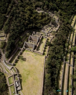
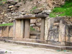
Late testimonies -such as those of Titu Cusi Yupanqui and the soldier Baltasar de Ocampo- suggest visits by friars extirpating idolatries and describe a population "on top of a mountain" with sumptuous buildings and great acllahuasi; references that many researchers connect with Picchu and with episodes of destruction, including the fire of the tower of the Temple of the Sun.This trajectory shows a continuity with transformations: from a residence and ceremonial center associated with Pachacutec, to a llacta in transition, partially depopulated and known by colonial authorities, but without frequent Spanish visits. Architecture and Engineering, how was Machu Picchu built?The greatness of Machu Picchu can be understood by visiting its urban and agricultural sectors and its ceremonial precincts. The Main Gate reveals the orthogonal design and access control: a narrow passage, trapezoidal walls and inclined spans that resist earthquakes. The Temple of the Sun -with finely carved ashlars- presents a curved enclosure of astronomical and funerary significance; under it, a carved rock leads to what is known as the Royal Mausoleum.
The House of the Inka, strategically located, articulates patios, enclosures and accesses, perhaps with temporary use on ritual dates. The Ceremonial Fountains cascade down to the Temple of the Condor, where the natural rock works as a living sculpture: the head of the bird is suggested on the ground, the wings in vertical outcrops, and the adjacent enclosure dialogues with the cult of the earth and the ancestors.The Sacred Plaza organizes the complex next to the Main Temple, a space for ritual meetings and observation of the firmament. The Intihuatana Pyramid crowns the acropolis with its famous stone "where the sun is tied", a ritual observatory to mark solstices and agricultural rhythms. Nearby, the Sacred Rock and the Hall of Mirrors (two polished depressions) complete a landscape designed for viewing: the walls guide perspectives toward the tutelary mountains of the Apus and the Urubamba gorge.
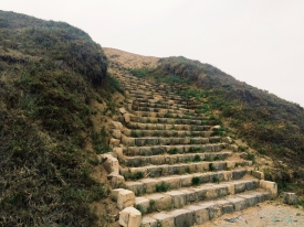
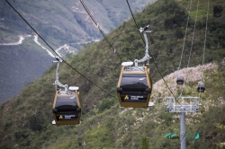
Agricultural terraces dominate the slopes with drainage and retaining walls that stabilize the terrain; they are pure engineering, but also landscape architecture. Throughout the site there are sectors of granite chaos: fractured blocks and quarries that show how the Inkas integrated living rock and ashlars in the same language.The llacta was built with anti-seismic techniques (polygonal ashlar, perfect joints, inclination of walls), millimetric control of runoffs and a planning that separates functions: religious-administrative above, residences and workshops below, and platforms surrounding the whole complex. The result is a city that dominates and dialogues with its surroundings, designed for processions, astronomical observations and rituals linked to water, the sun and the mountains. Territory, trails and biodiversity: the SHM-PANM that protects Machu PicchuMachu Picchu is located within the Historic Sanctuary of Machu Picchu - Machu Picchu National Archeological Park (SHM-PANM), a natural and cultural area of more than 37,000 hectares. The sanctuary integrates more than sixty archeological monuments connected by the Inka Trail Network (Qhapaq Ñan). This system articulated ravines and peaks through transversal and longitudinal routes, allowing the movement of people, products, and rituals. In the Machu Picchu corridor, paved stretches, stairways, tunnels, and bridges have been identified that adapt engineering to the Andean-Amazonian geography, linking the humid highlands with montane forests and jungle belts.The sanctuary's altitudinal gradient ranges from approximately 1,900 to 4,000 m above sea level, creating an exceptional ecological mosaic. It is one of the most biodiverse places in Peru: cloud forests, high Andean grasslands, and riparian zones are home to Andean bears, deer, taruca, cock of the rock, toucans, hummingbirds, reptiles, amphibians, and a rich flora of orchids, bromeliads, and tree ferns. The mist - the main feature of the photographs - is part of the water cycle that feeds the site's springs and fountains. Understanding Machu Picchu requires looking beyond its walls: the landscape is its ritual scenery and its life support.This territorial perspective also dismantles the myth of the "hidden city". Machu Picchu was a node in a larger network, with checkpoints, tambos and agricultural centers; its supply depended on terraces in neighboring valleys, and its symbolic function radiated through routes that connected with Cusco and Vilcabamba. The modern traveler's experience - entering through a road, ascending platforms and gaining altitude to look at Huyana Picchu and the canyon - recreates, in a small way, that original choreography between walking, ascending and contemplating. From rediscovery to the present: museum, conservation and responsible visitationAlthough local communities and muleteers were familiar with the ruins, it was at the beginning of the 20th century that Machu Picchu entered the international spotlight. In 1911, Hiram Bingham visited the llacta and disseminated his photographs; in 1913, National Geographic published a special issue that put the site on the world map. Decades later, the State promoted research and conservation; in 1981 it was declared a Historic Sanctuary and in 1983 Machu Picchu was added to UNESCO's World Heritage List as a mixed property (cultural and natural). The chronology of studies and restorations shows that the site was not "discovered" out of the blue: it was the result of a chain of local, academic and state perspectives that integrated it into a long-term conservation project.To better interpret the city and its territory, visit the "Manuel Chávez Ballón" Site Museum (hours from 09:00 to 16:00). The museum exhibits pieces recovered from excavations, computer graphics, historical photographs and maps that explain the construction processes, ceremonial life and the meaning of the llacta. The museum complements the tour of the archaeological park and reminds us that Machu Picchu is part of a larger cultural system: roads, satellite centers and terraces that are still being studied.Traveling to Machu Picchu today implies a commitment to a responsible visit: respecting marked routes, not touching or climbing walls, not carrying plants or stones, and reducing waste. The routes and quotas seek to protect both visitors and the sanctuary's infrastructure and habitats. A good practice is to combine entrance by bus with a section of the Inka Trail or alternative authorized routes to experience the mountain as the ancients did: on foot, step by step, letting the mist reveal - and hide - the city.Final tip: arrive early or in less crowded slots, walk the high platforms first to get a panoramic view and then descend towards the Sacred Plaza, the Temple of the Sun and the Temple of the Condor. Finish at the Intihuatana Pyramid and contemplate the perfect geometry of terraces and walls against the green backdrop of the sanctuary. You will understand why this masterpiece - born under Pachacutec, nourished by roads and water, and guarded by mountains - remains the greatest symbol of the Andes.