Cantalloc Aqueducts, Peru: the Nasca water galleries of the desert
Water engineering in a landscape of scarcity
Near the city of Nasca on Peru’s southern coast, the Cantalloc Aqueducts make an ancient water system visible at human scale. Their low channels and distinctive spiral openings sit in a region where surface water is seasonal and the coastal desert is exceptionally dry. The familiar image is the circular shaft descending toward an underground gallery, but the system is more than a row of striking wells. It belongs to a wider network that captured groundwater, carried it through covered and open sections, and directed it toward reservoirs and cultivated land.
The location explains the engineering problem. Peru’s Ministry of Culture dossier submitted to UNESCO describes the Nasca basin as dependent on rain in the upper mountains, with intermittent streams and long periods when surface water is scarce. The galleries filtered water from the underground water table and conveyed it toward storage areas known as qochas before distribution. Researchers describe the puquios as serving irrigation and domestic needs in valleys where water was not reliably available on the surface. Their significance is practical: they helped people sustain life and agriculture in a difficult environment.
Cantalloc is one named component of this larger hydraulic landscape, not the whole system. UNESCO’s tentative-list dossier places the aqueducts across the Nasca, Taruga and Las Trancas valleys and refers to a register of 41 structures, while also noting that some have disappeared or changed. That 2019 inventory is not a current count of functioning channels. Nor should every visible segment be assumed to have the same age or condition. The surviving works are part of a living landscape where communities have maintained water infrastructure over time.
Reading the spiral openings and underground galleries
The spiral-sided openings are the feature that gives Cantalloc its instantly recognizable profile. They descend from the surface to covered galleries and allow access to sections that would otherwise remain hidden. The UNESCO dossier describes these openings as points for maintenance and ventilation along channels designed with a slight slope. Their shape is not only a visual signature: it reveals that the system had to be reached, inspected and kept working. The best way to look at them is as working infrastructure, not as isolated curiosities arranged for photographs.
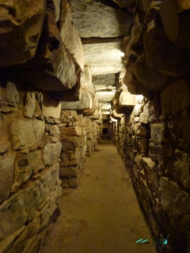
Below ground, filtration galleries intercept water moving through the subsoil and guide it along channels. Some sections are covered, others open to the air; the flow could then be collected in reservoirs and distributed to fields. The design depended on understanding local geology, the water table and the land’s gradient. It also depended on coordinated labor: a channel could not continue serving a community without periodic cleaning and repair. The UNESCO submission presents the system as a collective technical achievement, not a mysterious construction that appeared fully formed.
It is tempting to compare the puquios with other famous ancient waterworks, but comparisons should not erase their local purpose. Cantalloc responded to the particular conditions of Nasca’s dry valleys and irregular rivers. Its value lies in how a community adapted water capture and distribution to that terrain. The channels also remind visitors that archaeological remains may still be connected to present-day water use. Stay on marked public routes, do not enter shafts or channels, and avoid touching the stonework or interfering with water infrastructure.
What researchers know—and what remains debated
The age of the Nasca aqueducts is not a question to answer with a single confident date. Peru’s 2019 UNESCO tentative-list submission, drawing on archaeological research, proposes that construction may have begun around 300 to 500 CE. Schreiber and Lancho Rojas’ peer-reviewed study argues that the galleries were in use by the time of the Inca conquest and suggests that some may date to the later Nasca period. These are research-based interpretations, not a date stamped on every channel at Cantalloc.
Other scholarship adds an important caution: filtration-gallery technology was also built and managed in colonial Spanish America, and the existence of colonial systems elsewhere means that the form alone cannot prove a pre-Hispanic date. That discussion does not erase the evidence for Nasca-era use; it asks researchers to distinguish particular galleries, construction phases and periods of repair. A careful account therefore describes the archaeological arguments and makes clear where evidence is strong and where chronology remains under study.
The landscape has also changed through modern development and uneven maintenance. UNESCO’s dossier reports that some channels have been lost, abandoned or modified, while others have remained in use or undergone repair. Because that inventory was prepared for a tentative nomination in 2019, its totals should not be presented as a live visitor update. The proposal places the aqueducts on UNESCO’s Tentative List, a step in a possible nomination process; it is not the same as inscription on the World Heritage List.
Planning a responsible visit to Cantalloc
Perú Travel currently introduces the aqueducts among the attractions of the Nasca area and describes them as hydraulic engineering associated with the ancient Nasca. The public-facing information reviewed for this article does not provide a dependable current schedule or admission price for Cantalloc. Do not rely on an old blog, an unverified map listing or a quoted price without a date. Before travelling, confirm access arrangements with official local tourism or cultural services and check whether any conservation work has changed the visit.
Use Cantalloc as a chance to understand the water system in context rather than treating the spiral openings as a quick photo stop. Notice how the shafts sit along the channels, how covered and open sections relate, and why a reservoir mattered in a landscape of seasonal streams. The aqueducts are part of a larger network, so a single visit cannot stand in for every puquio in the valleys. A guide with archaeological or local knowledge can help distinguish the site’s documented features from popular explanations that go beyond the evidence.
Respect that water channels may have practical importance as well as archaeological value. Stay outside restricted areas, never descend into a gallery, and do not leave waste or remove stones. If a route or section is closed, follow the instruction; safety and conservation take priority over a closer view. Cantalloc’s story is not simply that ancient builders solved a puzzle. It is about how people learned to live with scarce water, organized maintenance across generations and kept an infrastructure connected to the land around Nasca.