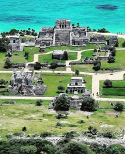
San Gervasio lies in the interior of Cozumel, about seven kilometres from the island’s present-day centre of San Miguel. It is not a single temple but a settlement of architectural groups linked by paths and raised roads known as sacbeob. INAH describes it as the island’s principal Maya city, one that controlled Cozumel and participated in political and commercial networks connected with Chichén Itzá. The scale becomes clearer when visitors look beyond the best-known shrine to the wider pattern of plazas, residences and ceremonial buildings.
Archaeological work has dated occupation at the site to around the third century CE, with substantial growth beginning several centuries later. INAH says the settlement expanded notably after about 1000 and that many of the buildings visible today belong to its later phase, between roughly 1200 and the Spanish arrival. These dates describe a long-changing community, not a city erected at once. The institution’s account also cautions that San Gervasio cannot be confidently equated with every settlement named in colonial chronicles.