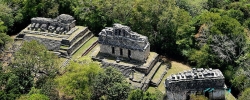
Palenque is one of the most compelling archaeological sites in Mexico’s state of Chiapas, where monumental Maya architecture rises from a humid tropical landscape. The ancient city, known in local history as Lakamha’, developed as a political and ceremonial centre during the Classic period. Its setting is not decorative background: streams, slopes and forest shaped how buildings were placed, while the present national park makes nature part of the visitor experience.
UNESCO describes the city as a major centre whose influence extended through the Usumacinta River basin, with its best-known period between roughly AD 500 and 700. The archaeological record presents a long history rather than one sudden foundation or a simple tale of abandonment. Palenque’s rulers, monuments and inscriptions illuminate political relationships and Maya thought, but the reasons for the city’s later decline are not fully settled. Responsible interpretation makes that uncertainty clear instead of filling it with a dramatic invented story.