About Wiñay Wayna
A hillside monument on the road to Machupicchu
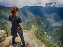
Wiñay Wayna is an archaeological monument on the Inca Trail network in Peru’s Historic Sanctuary of Machupicchu. It occupies a steep Andean slope above the Vilcanota valley, where stone paths connect the site with other monuments and the route toward the Inca city. It is not an independent roadside attraction: visitors encounter it as part of a controlled trail itinerary, and the conditions for reaching it depend on the route authorized for that date.
The name is commonly translated from Quechua as “forever young,” but it should not be turned into a promise about a spring or a health benefit. The older article’s tale that drinking from a sacred fountain restores youth is not supported by the official archaeological descriptions consulted for this account. The documented interest is more compelling: a carefully arranged ensemble of agricultural terraces, ceremonial areas, stone buildings, stairways, paths and water features integrated into a mountain landscape.
The site’s position explains why it can feel like a threshold in a longer journey. It is one of more than sixty archaeological monuments associated with the wider Inca road network at Machupicchu, whose routes link different elevations and environments. Wiñay Wayna is often approached on a trek, but a visitor should not assume that a particular overnight camp, trail segment or entrance is available without checking the current itinerary, ticket and conservation notices.
Terraces, buildings and a sophisticated water system
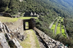
Official archaeological research describes Wiñay Wayna as a complex of ceremonial areas, rectangular buildings, stairways, passages and an extensive system of agricultural terraces. The terraces follow the mountain’s contours rather than forcing a flat grid onto the slope. Seen from a permitted viewpoint, their lines make visible the labor required to shape usable ground, manage runoff and connect cultivated areas with built spaces. They are also fragile heritage, not informal paths for visitors to climb across.
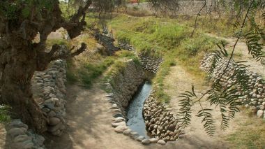
Water is among the site’s most striking features. The official monument inventory records eighteen phaqcha, or water features, alongside channels and related structures. Their presence shows the technical and spatial importance of water in the settlement. It does not justify assigning a single ritual explanation to every flow or claiming that every feature had one exclusive purpose. Archaeological interpretation distinguishes what is physically documented from broader ideas about Inca beliefs, and the careful visitor can appreciate both the engineering and the limits of what is known.
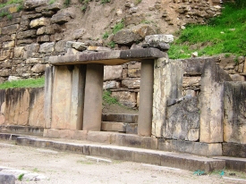
Stone stairways and narrow passages connect different levels of the complex. The architecture makes movement part of the experience: a change in elevation opens new views of the terraces, valley and surrounding forest. Buildings identified as residential or storage spaces sit alongside ceremonial areas, suggesting several kinds of activity within the monument. The arrangement should not be reduced to a single “temple” or imagined as a place used only by pilgrims; the physical evidence points to a more layered landscape.
What the Inca Trail adds to the visit
The official Machupicchu park page lists multiple authorized Inca Trail routes that include Wiñay Wayna, among them routes linking Piskacucho or Chachabamba with Machupicchu. These are managed heritage itineraries, not interchangeable hiking paths. The wider network extends for hundreds of kilometres and incorporates more than sixty monuments; conservation work is carried out on selected sections and sites each year. The trail’s cultural value and fragile mountain setting are why entry is regulated.
As of the latest dated notice checked for this article, the Culture Directorate of Cusco reported that routes 1, 2 and 3 reopened on 7 September 2026 after maintenance and conservation work. That is a dated operational update, not a promise about future availability. In April 2026, officials also described an alternative access arrangement after a landslide near kilometre 104. Such notices show how rain, slope failures and repair work can alter access. Recheck the official trail page and current bulletins shortly before travel.
Trail tickets are limited and administered separately from an ordinary visit to the Machupicchu citadel. Peru’s Culture Ministry published an advance reservation and payment process for 2026, with reservations handled through the government ticket platform and special rules for trail access. Those arrangements are year-specific; future inventory, route openings and authorized-agency requirements may change. Do not buy an informal promise of entry or arrive expecting that the archaeological monument can be reached without the required permit and route booking.
Practical planning and responsible travel
Before arranging transport, first decide which authorized route and date are actually available. A multi-day hike requires more planning than a viewpoint stop: confirm the ticket, operator and route details, understand where the itinerary begins and ends, and check whether the approved plan includes a visit to the Machupicchu citadel. The official trail page is the starting point; the ministry’s ticket platform and current Culture Directorate notices govern operational details. A permit for one route should never be assumed to cover another.
The mountain setting requires preparation for steep stone steps, changing weather, rain and variable temperatures. Wear footwear with reliable grip, carry water and layers, and follow the guide and control staff. Stay on the authorized path, keep away from unstable edges, do not touch or move stones, and pack out all waste. The archaeological features are part of a protected landscape where visitor movement, water management and vegetation all affect long-term preservation.
Wiñay Wayna rewards attention to the relationship between architecture and terrain. Look at how terraces stabilize the slope, how channels and fountains organize water, and how pathways join this monument to a larger route across the Andes. Avoid the unsupported legend of a fountain that grants youth; the real story is richer in evidence and more interesting for it. Because trail conditions and permits change, treat this article as historical and interpretive context, then verify access with Peru’s official authorities for the exact date of travel.