About Kaminaljuyu
An ancient city in the middle of a modern capital
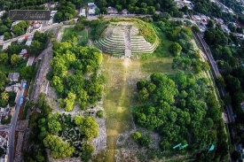
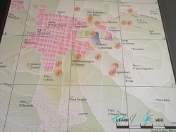
Kaminaljuyu is not a remote ruin reached after a long expedition. Its archaeological park sits inside Guatemala City, where traffic, neighbourhood streets and modern buildings surround a surviving fragment of a much larger Maya centre. That contrast is essential to understanding the site: visitors see only a protected portion of an ancient urban landscape that was progressively covered or altered as the capital expanded.
The Guatemalan Ministry of Culture describes Kaminaljuyu as one of the earliest and most important Maya urban centres. Its public information places the beginning of occupation around 1100–1000 BCE and its long decline around 850 or 900 CE. Dates vary across institutional summaries, so the safest description is a settlement that developed for more than two millennia, with changing periods of growth rather than one uninterrupted peak.
Its name is given by the Ministry in K’iche’ as “Hill of the Dead,” a reference associated with burials found in archaeological investigations. The label should not reduce the place to a cemetery. Kaminaljuyu was also a centre of public architecture, political organization, craft production and exchange across the highlands and the Pacific coast.
The setting was once different from today’s city. MCD accounts link ancient irrigation systems with Lake Miraflores, a body of water that no longer defines the urban landscape. Volcanic soils, access to obsidian and routes connecting the southern coast, highlands and Maya lowlands helped make this valley a strategic place for communities, although the precise extent of political control remains a scholarly question.
Trade, water and the rise of a highland centre
Archaeological evidence points to long-distance connections as a key part of Kaminaljuyu’s story. The Ministry describes the site as a node along routes between Guatemala’s Pacific coast, the highlands and the Maya lowlands. A 2026 MCD account also highlights obsidian and systems of irrigation associated with Lake Miraflores, reminding visitors that the city’s influence depended on landscape and infrastructure as well as monumental buildings.
The official cultural page places the development of public architecture and carved monuments in the Middle Preclassic period, approximately 1000–400 BCE. Those remains indicate a complex society taking shape well before the Classic-era cities that dominate popular images of Maya civilization. Kaminaljuyu’s chronology therefore broadens the story: political and urban life in the southern highlands had deep roots and its own regional character.
The ancient city did not remain static. The Ministry describes cycles of prominence and decline through the centuries, and the different chronological phases should not be compressed into a single golden age. Evidence of construction, exchange and settlement can change between periods, while the modern park preserves only selected places where those layers can be interpreted.
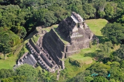
Its buildings were largely made from earth and adobe rather than durable cut stone. That construction, combined with the growth of Guatemala City, helps explain why much of Kaminaljuyu disappeared from view. The cultural ministry’s account says early explorers counted more than 200 mounds and that fewer than 40 remain. The figure describes a changing archaeological record, not a complete map of everything that once existed.
What the archaeological park preserves today
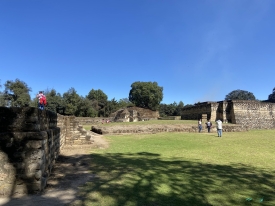
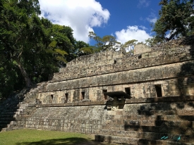
The modern park is a small window into that wider history, not a reconstruction of the entire ancient city. The Ministry identifies the Acropolis, the lower plaza of the Acropolis and La Palangana among the areas associated with the civic-ceremonial complex. These features help explain how public space was arranged, but today’s visitor should remember that most of the original settlement lies beneath the modern urban fabric or has been lost.
In September 2025, the Ministry announced public access to the lower plaza of the Acropolis after archaeological and conservation work. A later ministerial visit in April 2026 included the Acropolis, the lower plaza and the site museum. These dated notices show that the park continues to change through research and stewardship; they do not guarantee that every area will be open on any particular day.
The site museum adds interpretation through explanatory displays, replicas of monuments and archaeological ceramics, according to the Ministry. It is useful to visit the museum before or after walking the park: objects and explanations can make the low earthen platforms easier to read. The museum is a small interpretive facility, however, not a substitute for the larger collections held in Guatemala’s national museums.
Kaminaljuyu is also a place where preservation decisions remain visible. Urban expansion damaged many structures and erased plazas, courtyards and occupation layers beyond the protected mounds. The Ministry’s current conservation language stresses responsible visits and continued work. This history asks visitors to see the park not as a complete ancient city, but as a protected remnant that needs care within a living metropolis.
Visitor information and a more thoughtful way to explore
The Ministry’s Kaminaljuyu visitor page lists an address at 11 Calle 25-50, zone 7, Guatemala City. The same page lists daily park hours of 8:00 a.m. to 4:00 p.m. and guided visits Thursday through Sunday at 9:00 a.m.–12:30 p.m. and 1:30–3:00 p.m. The page has no clear recent revision date, so confirm the schedule directly before travelling.
The page also lists admission prices of Q5 for Guatemalan nationals and Q50 for foreign visitors, payable in local currency. Because this information appears on a page whose publication date is unclear, treat it as a posted reference rather than a guaranteed current tariff; ask the park about the price and payment method before arrival. Special events, conservation work or holidays may affect access.
Plan a visit around the compact public areas that are open, and allow time to read the museum interpretation rather than expecting a monumental skyline. Paths and earthen structures are vulnerable to wear, water and casual climbing. Stay on designated routes, do not step onto mounds or touch exposed remains, and follow staff guidance about photography and any sections temporarily closed.
Kaminaljuyu’s most compelling feature may be the way it complicates the idea of a lost Maya city. Here, archaeology sits within a contemporary capital, and a preserved plaza offers only a glimpse of a dense history shaped by water, trade, governance and urban change. A careful visit can leave the reader with a sharper sense of what survives—and of how easily the city around it can obscure what once stood there.