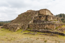
On the slopes of Cerro Bernal, also called Cerro de los Metates, the archaeological zone of Quiahuiztlán looks across the coastal plain of central Veracruz. The name comes from Nahuatl and is commonly rendered as “Place of the Rain.” This was not simply a cemetery: Mexico’s National Institute of Anthropology and History (INAH) describes it as a Totonac settlement that combined urban, funerary and defensive roles. Its setting explains much of its character: a high natural lookout above a fertile coastal corridor, rather than an isolated monument on level ground.
INAH places the site in the municipality of Actopan, about 30 kilometres north of Cempoala, and identifies Cerro Bernal as its landmark. A newer institutional feature also calls the hill Cerro de los Metates, referring to the quantity of those objects recovered there. From the ridge, the view reaches toward the coastal plain and the area associated with old Villa Rica. The landscape is part of the visit, but the archaeological remains are the reason to stop: platforms, ceremonial buildings, a ball court and carefully built tombs occupy the hillside.