Aerial Views of Our World Back to the full guide
Tlaxcala · Mexico · Street View

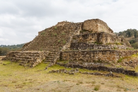
Tepeticpac Archaeological Site — Street View

Walk around Tepeticpac Archaeological Site at street level, then read the full guide with photos, videos and sources.

Tepeticpac was one of the four altepetl (polities) that made up the confederation of Tlaxcala. It was the northwest-most altepetl, located west of the Atzompa river and north of Quiahuiztlan.

The site is in the present day state of Tlaxcala in central Mexico.
Read the full guide

Where it is: Tlaxcala de, Mexico · 19.3090765, -98.2413961

Street View nearby

Cacaxtla
Cacaxtla San Miguel , Mexico · 13 km away
Cantona Puebla, Mexico · 83 km away