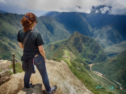
Above the modern town of Pisac, an Inca archaeological landscape climbs a narrow Andean ridge at about 3,400 metres. Its terraces follow the mountain’s contours; stone paths, stairways, channels and doorways connect agricultural, residential and ceremonial areas. The site is not one isolated temple but a large park whose layout makes the relationship between architecture and terrain unusually visible. For travellers moving through the Sacred Valley, Pisac offers a chance to slow down and read how an imperial settlement was fitted to a steep landscape.
The Cusco Directorate of Culture places Pisac about 33 kilometres from Cusco along the road toward Calca, with a further nine kilometres from the modern town to the archaeological park. The elevation is more than a logistical detail. Walking uphill over irregular stone at altitude can feel demanding even for active visitors, so acclimatisation, water and an unhurried pace matter. The official route includes steps cut into bedrock, and the cultural authority says the terrain does not allow a flat, fully accessible path through the park.