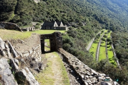
Across the river from Ollantaytambo’s monumental sector, Pinkuylluna climbs a steep hillside whose stone buildings are visible from the town below. The archaeological site is not simply a scenic lookout: its rectangular rooms and terraces belong to the wider landscape of the Inca settlement. From the trail, visitors can read the relationship between high storage structures, the urban grid, agricultural terraces and the routes that meet in the Sacred Valley.
Peru’s tourism inventory places the site at about 2,851 metres above sea level and describes two architectural sectors. Sector A, nearest the settlement, contains twelve rooms arranged on platforms that also retain the slope. Sector B includes three long, two-level rectangular buildings in parallel rows, with smaller terraces nearby. The municipal tourism portal identifies the principal buildings as structures likely used as qollqas, or storehouses; that interpretation is more precise than calling every ruin on the hill a granary.