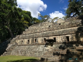
Tazumal stands in the city of Chalchuapa, in El Salvador’s Santa Ana department, about 80 kilometres west of the capital, San Salvador. The Ministry of Culture places it within an archaeological zone of roughly ten square kilometres that also includes places such as Pampe, El Trapiche, Las Victorias, San Francisco, Nuevo Tazumal and Casa Blanca. This landscape matters because Tazumal was part of a dense history of settlement, not an isolated pyramid surrounded by empty countryside.
The ministry describes Chalchuapa as a long-lived community with its own cultural character and influences associated with Maya, Teotihuacan and Toltec groups. It says occupation in the wider area reaches back to the Early Preclassic, around 1200 BCE, and continued through later periods. UNESCO’s Tentative List entry likewise describes at least 3,200 years of human occupation in present-day Chalchuapa. These broad timelines refer to the region and successive communities; they should not be turned into a claim that one unchanged population or political system lasted continuously.