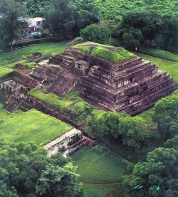
Tak’alik Ab’aj stands in the municipality of El Asintal, in Guatemala’s Retalhuleu department, where the Pacific piedmont rises toward the Sierra Madre. The national tourism institute places the archaeological park at about 600 metres above sea level, amid a landscape shaped by volcanic slopes and the humid lowlands below. It is not a single isolated pyramid: the site is an ancient urban and ceremonial centre whose monuments, plazas, drainage works and natural setting should be read together.
UNESCO describes a history extending from about 800 BCE to 900 CE, a span of roughly 1,700 years. The site is especially important for the transition from Olmec cultural expressions to early Maya culture. That change was not a simple replacement of one people by another. Tak’alik Ab’aj preserves evidence of contact, adaptation and exchange, visible in sculpture, architecture and material remains that connect the Pacific coast with communities much farther away.