Mount St. Helens: a living volcano, a changed landscape and a careful visit
A mountain whose outline tells a story
Mount St. Helens does not have the familiar, symmetrical profile of a quiet cone. Its summit is a horseshoe-shaped crater, opened when the volcano’s north flank collapsed on May 18, 1980. The change is visible from viewpoints across southwestern Washington, but the mountain is more than a dramatic silhouette: it is an active volcano surrounded by forests, lakes, river valleys and communities whose lives are connected to its changing landscape.
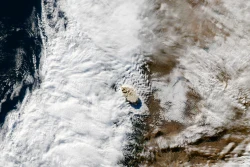
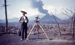
The eruption followed weeks of earthquakes and visible deformation. At 8:32 a.m. on May 18, a magnitude 5.1 earthquake preceded the collapse of the unstable north side. The landslide removed support from pressurized magma and triggered a lateral blast, ash column and volcanic mudflows. The U.S. Geological Survey records 57 deaths. The event became a turning point in American volcanology because it showed how close observation, public communication and hazard planning can save lives even when an eruption cannot be stopped.
More than four decades later, the mountain is not frozen in 1980. A lava dome grew in the crater during later activity, and scientists continue to monitor earthquakes, deformation and gas. Mount St. Helens is therefore a place where a visitor can see the consequences of a major eruption while also remembering that volcanic landscapes remain dynamic. A quiet day or a low alert level is not a guarantee that hazards have disappeared.
From disaster zone to an outdoor laboratory
In 1982, the United States established the Mount St. Helens National Volcanic Monument within Gifford Pinchot National Forest. The designation set aside about 110,000 acres for research, recreation and education. Much of the blast zone was left to respond naturally to the eruption, creating an unusually extensive setting in which scientists could study ecological recovery rather than immediately replant every damaged area.
The resulting landscape is not a simple tale of lifeless ash becoming green again. Some slopes were stripped of vegetation; other patches survived in the lee of ridges, and plants and animals returned through multiple pathways. Researchers have followed how soil, water, insects, plants and larger wildlife interact over time. The Monument makes that process legible: a view across the Toutle River valley can reveal bare deposits, young growth and older forest within one frame.
That scientific story sits alongside human history. The volcano’s 1980 eruption affected residents, workers, tribal communities and public agencies across the region. The names of David Johnston and other people who died are not merely labels on a map; they recall the work and loss behind the monitoring systems used today. Interpretive exhibits at visitor facilities help explain both the physical sequence of the eruption and the decisions people faced as warnings developed.
Plan around access, not an old map
There is no single entrance that makes every part of Mount St. Helens equally reachable. Roads approach different viewpoints and facilities, and distance on a map can understate the time needed to cross the forested region. The Mount St. Helens Visitor Center at Silver Lake, near Castle Rock, offers exhibits and orientation. Its posted schedule and admission information can change, so check the Washington State Parks page before setting out rather than relying on a saved itinerary.
Johnston Ridge Observatory stands close to the 1980 blast zone and has long been one of the most revealing places to view the crater. A 2023 landslide damaged access on State Route 504 and cut off the upper highway. In notices available on October 9, 2026, Washington State Parks still described the Observatory as closed pending road repairs in 2027; WSDOT updates described bridge and roadway work followed by repairs to the facility. Treat that as dated information, not a promise of a reopening day: confirm the road, observatory and any restrictions directly with the agencies before travel.
Other parts of the monument may operate on different seasonal schedules. The U.S. Forest Service and partner organizations publish notices for roads, trails, caves and recreation areas; some activities require permits, including climbing above designated elevations. Weather, snow, wildfire, erosion and construction can change access quickly. Verify the specific destination you intend to visit, and do not assume a road shown on a general map is open to the public.
How to read the landscape responsibly
Give the mountain time. At a safe overlook, look for the crater rim, the dome and the channels cut by water through deposits left by the eruption. A pair of binoculars can help distinguish features that seem like a single gray slope from a distance. Interpretive displays are useful before or after a viewpoint because they connect what is visible to the sequence of collapse, blast, ashfall and recovery.
Safety here is practical, not theatrical. Follow closures and posted boundaries, remain on authorized routes, and carry layers, food and water appropriate to a remote mountain outing. Mobile coverage is unreliable in parts of the region, and conditions at higher elevations can differ sharply from those near the highway. Anyone planning a climb should consult the Forest Service permit rules and current weather and volcano information; a scenic visit is not the same undertaking as entering a restricted or exposed area.
Mount St. Helens rewards visitors who arrive with curiosity rather than a checklist. Its story includes an immense natural event, the people who experienced it, the research that followed and an ecosystem still changing. Because roads and facilities can be affected by repair work and the volcano continues to be monitored, the best final step before departure is to check official updates. That small act helps keep a journey grounded in what is open, safe and verifiable today.