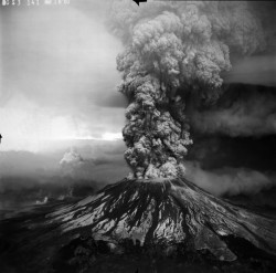
Cleveland Volcano, Alaska: remote Aleutian geology and risk
Mount Cleveland rises from Chuginadak Island in Alaska’s remote Aleutian chain, a nearly symmetrical cone whose clean outline belies a restless history. It is not a conventional visitor attraction with a road, trailhead or public visitor center. The Alaska Volcano Observatory (AVO) places the nearest community, Nikolski, about 73 kilometres to the northeast and lists Unalaska roughly 255 kilometres away. For most readers, Cleveland is best understood as a striking and hazardous volcano in a sparsely inhabited maritime landscape—not a mountain to approach casually.
A cone on an island at the edge of the Pacific
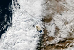
AVO describes Mount Cleveland as a stratovolcano that forms the western half of Chuginadak Island, about 40 kilometres west of Umnak. The island belongs to the Islands of Four Mountains, within Alaska’s Fox Islands and the broader Aleutian arc. Cleveland reaches 1,730 metres (5,675 feet), the highest point in that island group. A narrow, low strip joins the volcano’s western mass to the more rugged eastern side of Chuginadak, where lower cones and eroded valleys give the island a more broken profile.
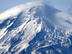
The upper cone is notably smooth compared with the deeply cut lower slopes. AVO’s geological description notes that the lower flanks become more irregular below about 300 metres, while the upper cone is comparatively undissected. The contrast is a reminder that volcanic shape is a record of several processes at once: eruptions build the cone, while erosion and glaciers carve the surrounding terrain. The view from a map or satellite image can make the form look simple; the island itself is a more complex combination of volcanic deposits, weather and rugged coastal relief.
A history measured through eruptions
The Alaska Volcano Observatory’s record includes reported eruptions spanning centuries, with historical entries from 1774 onward. Some early events are marked uncertain, so a long list should not be mistaken for a perfectly complete instrument record. More recent activity is better documented. Cleveland erupted repeatedly in the late twentieth and early twenty-first centuries, including events in 2001, 2005, 2009, 2010, 2011, 2013, 2016, 2017, 2019 and 2020. Episodes can involve explosions, ash emissions, lava extrusion and the growth or collapse of a summit dome.
The June 1944 eruption remains especially important in Alaska’s volcanic history. AVO records two days of explosive activity, ash and tephra, and lava flows extending from the summit area. The observatory identifies Cleveland as the source of the only reported historical death in Alaska directly attributed to volcanic activity. That fact is not a reason to sensationalize every episode; it is a reminder that even a remote volcano can have consequences far beyond its slopes, particularly when ash enters air routes across the North Pacific.
Why Cleveland matters to aviation
Ash is the hazard that makes Cleveland especially relevant to aircraft. Fine volcanic particles can travel high into the atmosphere and damage jet engines, sensors and other equipment. The volcano lies in a region used by flights crossing the North Pacific, while its remoteness means an eruption may be difficult to observe directly from the ground. AVO therefore combines seismic instruments, satellite observations, web cameras and reports from pilots or mariners. Not every monitoring method is equally available at all times, and observations can be limited by weather and the isolation of the island.
AVO’s public profile displays an aviation color code and volcano alert level, along with recent activity entries. The page available for this article shows GREEN/NORMAL following an update dated 8 July 2024, but it also says there have been no newer Cleveland updates on that page. That dated reading must not be presented as a live guarantee of present conditions. Pilots, operators and anyone whose plans depend on nearby airspace should consult AVO’s current notices and the relevant aviation authorities immediately before travel or flight operations.
The name and the human landscape
The volcano’s name has a documented but qualified origin. AVO says Mount Cleveland was named in 1898 by surveyor John A. Flemer, possibly for Grover Cleveland, who was then a former U.S. president. The island name Chuginadak has a separate Aleutian cultural history, but broad claims about traditional beliefs should be attributed carefully and not treated as a visitor anecdote. The Aleutian Islands are Indigenous homelands as well as a geologic arc, and the record of exploration and naming does not erase that enduring relationship.
There is no ordinary road-based itinerary for Cleveland in the observatory’s visitor information. Its remote island setting and volcanic hazards make it fundamentally different from an accessible national-park trail. The nearest named settlements in AVO’s profile are far away, and the agency’s pages focus on monitoring, research and hazard communication. Readers interested in the volcano can follow its official activity reports, maps and camera feeds rather than interpreting a satellite image as an invitation to land or climb.
How to follow the volcano responsibly
For a current picture, use the Alaska Volcano Observatory’s Cleveland page and alert system, noting the date and time attached to every update. A quiet camera, a normal alert or a lack of new reports is not a promise that conditions cannot change. Volcanic status is an operational matter; aviation decisions belong to the responsible authorities, not to a travel article. Researchers and pilots should use the technical products and notices intended for their work.
Cleveland’s appeal lies in the tension between a remarkably regular cone and a landscape that remains active and remote. Its profile tells a story of construction by eruptions, its archive preserves episodes from 1944 to the present, and its ash hazard connects a small Aleutian island to trans-Pacific travel. Understanding the place means resisting the urge to turn it into a casual excursion. It is a volcano to learn about through current science and respectful attention to the Aleutian setting, not a destination with an assured public route.