Mount Pinatubo: the crater lake, a 1991 turning point and a safer journey
A landscape remade in June 1991
Mount Pinatubo rises in the Zambales Mountains of central Luzon, where the provinces of Zambales, Tarlac and Pampanga meet. Before 1991, much of the lowland population knew the mountain as a distant, forested presence. The climactic eruption of June 15 changed its summit and the surrounding valleys, producing a broad caldera and a landscape of ash, pumice and volcanic mudflows. Today, the crater lake and pale lahar terrain draw visitors, but the view is inseparable from a disaster that reshaped communities and scientific understanding.
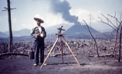
The eruption did not arrive without warning. On April 2, 1991, small explosions and steam were reported on the upper slopes. Indigenous Aeta residents were among the first to notice signs and communicate them to researchers; PHIVOLCS then established monitoring and warning work. Strong explosive activity began in June and culminated on June 15, when ash and pyroclastic flows spread across the region. The chronology matters because it shows how local observation, scientific monitoring and public evacuation operated together under intense uncertainty.
The event also reached far beyond the mountain. Typhoon Yunya crossed the Philippines during the climactic eruption, helping spread wet ash over a wider area. NOAA records that enormous quantities of sulfur dioxide entered the stratosphere and were dispersed globally, producing measurable atmospheric and climate effects. These consequences explain why Pinatubo is discussed in volcanology, disaster planning and climate research as well as in travel writing.
People, evacuation and the long aftermath
Pinatubo’s human story is not a brief prelude to a scenic lake. The Aeta communities have long lived on and around the mountain, with ties to its forests, slopes and rivers. The 1991 crisis forced many people to leave homes and livelihoods as danger zones expanded. USGS research on warning responses records how reports from Aeta residents helped bring the volcano to scientific attention, while also documenting the difficult decisions families faced when evacuation meant leaving land, crops, animals and community life behind.
The eruption’s immediate destruction was followed by years of lahars—water-saturated flows of volcanic debris—especially during heavy rain. Ash and loose deposits altered river channels, and later rains carried sediment into lowland settlements and farmland. Recovery was therefore not a single moment when the eruption stopped. It involved repeated hazard assessments, relocation, rebuilding and continued attention to river systems that could remain dangerous long after the major explosions.
The sequence shows why warnings depend on more than instruments alone: local observations, scientific monitoring and communication with residents all mattered. That history deserves space in any visit. A landscape may appear quiet while retaining hazards, and the communities most closely connected to it should not be reduced to a backdrop for adventure tourism. Visitors can learn more by recognizing that local knowledge and public science both belong in the story of Pinatubo.
Reaching the crater requires current local coordination
The Philippine Department of Tourism describes the crater lake as a destination commonly reached through Capas, Tarlac, with access also associated with Botolan, Zambales; it cautions that operational conditions can change. The municipal government of Capas identifies Santa Juliana as a tourism service point and describes organized trips involving off-road vehicles and a walk through the lahar landscape. These details are not a guarantee that a route is open on a particular day. Weather, trail conditions, local decisions and volcanic advisories can alter or suspend access.
Do not treat a crater excursion as an independent roadside hike. The 2025 Capas citizen charter describes booking through an accredited tour operator and lists requirements that vary with age and visitor circumstances. Fees, inclusions, departure rules and health documentation may be revised, so contact the municipal tourism office or an authorized operator for current instructions before paying or traveling. Avoid relying on social-media posts or old package lists as proof of present access.
PHIVOLCS maintains the authoritative alert system. The status page available on October 9, 2026, showed Pinatubo at Alert Level 0, but a low alert is not a travel clearance. PHIVOLCS also states that entry into the six-kilometer Permanent Danger Zone is not advised because phreatic explosions and ash puffs can occur without precursors. Conditions and guidance may change after this article’s research date; follow current PHIVOLCS bulletins and local government restrictions, and do not enter a closed or restricted area.
What to notice—and what not to assume
The journey is as much about terrain as destination. Lahar deposits form broad channels and ridges, and the color and texture of the ground shift with light, moisture and recent weather. At the crater, the lake occupies the caldera left by the 1991 eruption. Its appearance can vary; photographs that show a particular shade or water level should not be treated as a promise of what a visitor will see on arrival.
Preparation should match a remote, exposed outing. Confirm the approved meeting point, operator, route and departure conditions; ask what food, water, clothing and medical documentation are required; and carry only equipment permitted by the local authorities. A 4x4 ride does not remove the need for walking on uneven volcanic ground. Heat, rain, slippery surfaces, river crossings and limited communications can make a seemingly short itinerary demanding. Follow the guide and any official closure instructions rather than attempting an alternate path.
Mount Pinatubo is rewarding when approached as more than a dramatic crater. It is a volcano whose 1991 eruption linked local observations to scientific warnings, displaced communities and sent atmospheric effects around the world. The lake is one chapter in that continuing story, not evidence that all hazards are past. Before planning a visit, check PHIVOLCS, the tourism office responsible for the chosen route and the operator’s current requirements. That is the difference between an attractive image and a journey grounded in respect, safety and verifiable information.