Mount Batur, Bali: caldera landscape, culture and visitor guide
A volcano at the heart of a wider landscape
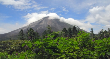
Mount Batur rises in the Kintamani highlands of Bali’s Bangli Regency, within a landscape that is much larger than a single summit. UNESCO’s description of the Batur UNESCO Global Geopark places the volcano among villages, farmland, Lake Batur and geothermal features. The setting rewards visitors who look beyond the familiar sunrise ascent: the caldera walls, water, cultivated slopes and Balinese Hindu places of worship form a connected landscape whose geology and everyday life are difficult to separate.
The mountain is an active stratovolcano, and UNESCO gives its height as 1,717 metres. It sits inside a younger caldera nested within a larger caldera, a structure that explains the broad basin and dramatic rim visible from viewpoints around Kintamani. The geopark’s UNESCO profile says the volcano has erupted at least 22 times between 1804 and 2000. That record is a reminder that Batur is a living geological system, not simply a scenic backdrop or a dormant hill.
Reading the caldera and Lake Batur
Lake Batur occupies part of the larger caldera and curves along the base of the inner volcanic cone. UNESCO describes it as a crescent-shaped lake about seven kilometres long and 1.5 kilometres wide. The combination of crater rim, lake and active cone makes the area an unusually legible place to understand how volcanic landforms shape a region. From above, the water appears enclosed by steep slopes; at ground level, roads and settlements trace the contours of the basin.
The lake is also more than a geological feature. UNESCO’s World Heritage account of Bali’s subak landscape identifies Lake Batur and the nearby water temple Pura Ulun Danu Batur among the components of a cultural system in which water, agriculture and religious practice are linked. The lake’s position in the caldera helps explain why it matters to communities beyond the immediate shoreline. A visit can therefore move from a view of volcanic topography to a conversation about how people understand and manage water.
Geology, living culture and the geopark
UNESCO designated Batur a Global Geopark in 2015. The area covers 36,640 hectares and includes 15 villages in Kintamani, according to UNESCO’s geopark profile. Its purpose is not only to present rocks and landforms: the designation connects geological heritage with education, conservation and local livelihoods. Agriculture and tourism are important parts of the local economy, and visitors encounter a working highland region rather than a landscape set aside exclusively for sightseeing.
The cultural story is especially visible in Bali’s subak system, the cooperative management of irrigation water through canals, associations and water temples. UNESCO’s World Heritage listing explains that the system expresses the Balinese philosophy of Tri Hita Karana and has historical roots extending back many centuries. The Batur geopark overlaps with parts of that wider cultural landscape. This does not mean every viewpoint or village is itself a World Heritage component; it means the natural setting and the island’s water-management traditions are closely connected.
What visitors can experience
Many travellers come for a guided climb timed to reach the summit around sunrise, an activity highlighted by UNESCO as one way to experience the geopark. Others stay lower, visiting lakeside areas, looking across the caldera from Kintamani, or learning about the region through local food and settlements. UNESCO also notes geothermal hot springs and products associated with the area, including Kintamani oranges, coffee and local crafts. These experiences vary by operator and season, so they should be treated as options to verify rather than a guaranteed package.
A broader itinerary can include the villages and cultural sites around the basin instead of treating the summit as the only destination. Pura Ulun Danu Batur is important in UNESCO’s account of the subak landscape, while the lake and surrounding farms help reveal the relationship between water and agriculture. Geopark education initiatives also use museums and monitoring facilities to explain volcanic processes and risk. Check each attraction’s own visitor information before travelling; the UNESCO designation does not establish a shared ticket, common opening hours or a single visitor centre schedule.
Safety, access and how to plan
Because Mount Batur is active, climbing conditions and access can change with volcanic activity, weather and local decisions. This guide does not claim a current alert level or that a particular route is open. Before setting out, consult Indonesia’s official MAGMA volcano information portal and follow current instructions from local authorities and licensed guides. A sunrise departure also means travelling in darkness and over uneven volcanic ground; appropriate footwear, warm layers, water and a realistic assessment of fitness are essential.
There is no single public timetable or admission arrangement for the whole geopark, and a summit trek, museum visit, hot spring and lakeside stop may each have different operators and fees. Confirm transport, guide arrangements, weather, opening information and any activity restrictions directly before departure. The strongest reason to spend time at Batur is the way the pieces fit together: an active volcano, a water-filled caldera, village life and a cultural landscape shaped by shared irrigation. Taking time to understand those connections makes the visit more meaningful than collecting a sunrise photograph alone.