Manam: the inhabited volcano that keeps reshaping an island
An island built around a summit
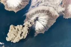
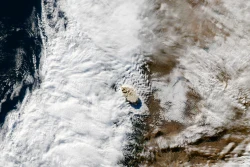
From above, Manam’s outline is almost a lesson in volcanic geography: a roughly circular island, a high central cone and channels running toward the sea. Yet this is also an inhabited place, with a history that cannot be reduced to a spectacular eruption photograph. In Papua New Guinea’s Madang Province, Manam brings the timescale of a growing volcano into direct contact with the much shorter timescale of homes, gardens and decisions about evacuation.
The island rises from the Bismarck Sea about 13 kilometres off the mainland’s northern coast. The Smithsonian’s Global Volcanism Program lists the summit at 1,807 metres and describes an island approximately 10 kilometres across. Manam is a stratovolcano, built from successive deposits of lava, ash and other erupted material. Its height and compact footprint explain how closely the summit, steep flanks and coastal settlements belong to one physical system.
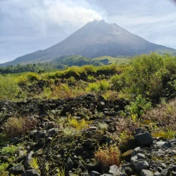
Two active summit craters, commonly called Main and South, sit above four prominent radial valleys. Those valleys have channelled lava and pyroclastic flows, the dangerous mixtures of hot gas, ash and rock that can move down a volcano’s slopes. Some past flows reached the coast. The dark tracks visible across vegetated ground are therefore more than visual features: they record pathways along which destructive material has travelled.
The eruptions that changed life on the island
Recorded eruptions extend back to 1616, according to the Global Volcanism Program. The long chronology does not mean that activity has been constant or identical. Manam alternates between different intensities and forms of eruption, and the summit’s appearance on one clear day cannot describe its future behaviour. A faint plume, a stronger ash emission and a destructive flow belong to related processes with very different consequences for the people below.
The eruptions beginning in late 2004 transformed the island’s recent history. Japan’s Foreign Ministry, announcing emergency aid on 2 December that year, documented October eruptions, ash damage to reservoirs and fields, and evacuations toward Mangem and Bogia on the mainland. The relief supplies included shelter materials, water containers and purification equipment. Those practical objects reveal what volcanic displacement means beyond the dramatic image: clean water and somewhere to live can become immediate needs.
Later scientific accounts described devastation during the 2004–2006 eruptive period, including destroyed crops and contaminated water. Evacuation did not erase the relationship between people and their island. Some residents subsequently returned, as later research and monitoring accounts describe. A return is evidence of an inhabited place and difficult choices, not evidence that the volcano has become safe. Nor should figures from different emergency reports be treated as a present-day population census.
Reading the gases without entering the crater
Manam has also become a site of scientific work on volcanic gases. In October 2020, the University of Manchester described an international ABOVE research project combining adapted drones, ground instruments and satellite measurements. The team included Papua New Guinea expertise and worked with the Rabaul Volcano Observatory. The aim was to obtain measurements near an active summit where conventional sampling would expose people to serious danger.
The drones carried miniaturised sensors and sampling equipment into the plume. Researchers combined those measurements with satellite observations of sulphur dioxide, including data from the TROPOMI instrument. Comparing carbon dioxide and sulphur dioxide helps scientists investigate magma processes and the sources of volcanic carbon. Such work improves understanding and monitoring; it does not turn a complex volcano into a machine whose next eruption can be given a guaranteed date.
The research account also connected scientific instruments with community communication. Following the fieldwork, researchers raised funds for computers, solar panels and satellite communication support, and for drone training for observatory staff. These were developments reported in 2020, not a claim about the condition of every system today. They show why monitoring is more than watching a summit: information has to reach people who may need to act on it.
A landscape that remains active
Recent evidence makes the continuing hazard concrete. The Global Volcanism Program’s weekly report for 8–14 October 2026, citing the Darwin Volcanic Ash Advisory Centre, recorded ash plumes reaching 2.1 kilometres above sea level during several days that week. The altitude is measured from sea level, not above the crater. This dated observation establishes recent activity; it is not a live forecast or a declaration of safe conditions later in the month.
Australia’s Papua New Guinea travel advice, updated on 7 September and current on 29 October 2026, advises a high degree of caution nationally, with higher levels in some areas, and explicitly identifies Manam among active volcanic locations. It calls for following local authorities and monitoring ash information. Manam should not be treated as a routine crater excursion; any decisions about movement must respect current local disaster and volcanological guidance.
The island’s significance is the conjunction of landform and lived history. Its valleys explain the movement of erupted material; the evacuation record explains the disruption of water, crops and homes; research explains the effort to understand what happens beneath the summit. Keeping these stories together gives Manam a more truthful place on the map: an active volcanic island that is also a home, not merely an isolated cone in a blue sea.