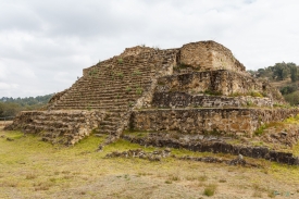
Zultépec-Tecoaque is an archaeological zone near Calpulalpan in the Mexican state of Tlaxcala. Its position on a route through central Mexico made it a place of exchange and political contact before the Spanish invasion. The National Institute of Anthropology and History, INAH, identifies the settlement with the Acolhua, a Nahua-speaking people whose principal center was Texcoco and who belonged to the political alliance commonly called the Triple Alliance. The surviving site is not just a battlefield memorial: it preserves urban spaces, religious architecture and evidence of daily life.
INAH reporting describes the town as an Acolhua frontier community and places it within a wider network of routes connecting major Mesoamerican centers. Its temple precinct included a sanctuary associated with Ehecatl, the wind aspect of the deity Quetzalcoatl. Archaeological remains and recovered objects help researchers examine how local ritual, trade and political authority interacted. The site’s importance lies partly in this regional perspective: the events of 1520 occurred in a populated Indigenous landscape with its own institutions, not on an empty stage awaiting European arrival.