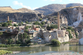
Van Fortress rises on a long rock ridge overlooking the plain and the eastern shore of Lake Van. The Van Governorate places the site about five kilometres from the modern city centre and describes the natural outcrop as roughly 1,800 metres long, with steep southern faces and a gentler northern approach. Its height and commanding position explain the attraction of the ridge, but the setting is more than a scenic backdrop: the fortress was built to oversee the landscape around Tushpa, the Urartian capital that occupied this region.
The governorate dates the fortress’s foundation to Urartian king Sarduri I, around 840–825 BCE. In antiquity the capital was known as Tushpa. The official account describes the stronghold as a three-part complex and lists rock-cut foundations for walls, defensive circuits and towers. These remains should not be mistaken for one fully preserved palace. They belong to a long-lived fortified place whose surviving features record different phases of construction and use.