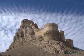
On Arin Berd hill in southeastern Yerevan, the remains of Erebuni preserve an unusually precise point of departure for a city’s history. A cuneiform inscription associated with Urartian king Argishti I records the foundation of the fortress in 782 BCE. Yerevan’s municipal and visitor portals use that evidence to mark the city’s traditional recorded beginning, while the archaeological site itself reveals a fortified centre built in the ancient Kingdom of Urartu.
The inscription is more than a date carved into stone. It was a statement of royal authority and a record of a strategic foundation in the Ararat plain. Yerevan’s visitor information says the text was discovered during excavations on Arin Berd in 1950; the city’s historical account links it to the year 782 BCE. The connection between Erebuni and modern Yerevan is central to the capital’s civic memory, though the ancient fortress and the later city should not be treated as identical places.