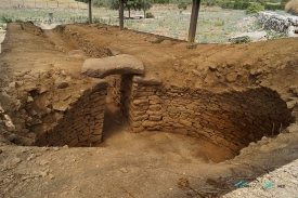
Eight kilometres from Nafplio, the archaeological site of Tiryns rises from the Argolid plain as a low rocky hill surrounded by farmland. Its outline is less dramatic than a mountain fortress, yet the walls enclosing its summit reveal why this was one of the most striking strongholds of Mycenaean Greece. The site is best read as a layered settlement: people lived here long before the palace and fortifications that dominate the surviving remains.
The Ephorate of Antiquities of Argolida traces occupation back to the Neolithic period, between the seventh and fourth millennia BC, based on pottery from deep archaeological layers. The earliest architectural remains date to the third millennium BC. On the southern rise of the hill, a circular structure about 27 to 28 metres in diameter was built during the Early Bronze Age. Its precise purpose remains debated; proposals have included a fortified palace, a monumental tomb or a sanctuary.