About Derawar Fort
A landmark rising from Cholistan’s Rohi desert
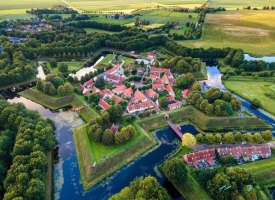
Derawar Fort rises above the flat desert of Cholistan in Punjab, Pakistan, where its massive walls and round bastions make a striking landmark across the Rohi landscape. The fort is often introduced through a dramatic origin story, but its early centuries are not settled history. Pakistan’s archaeology department says little is known about that period before the fort was captured in 1733.
The region around it has a deeper human past. Pakistan’s 2016 UNESCO Tentative List submission describes Cholistan as part of the wider Thar desert and notes archaeological evidence of settlements along the former Hakra river from about 4000 to 600 BCE. That is regional context, not proof that Derawar itself dates to those settlements.
Some official accounts attribute an earlier fort to Rai Jajja Bhatti in the ninth century. The archaeology department’s own entry, however, says the fort’s early history is not well documented and begins its clearer account with the 1733 capture. A careful visitor can hold both points in view: the older date is a reported tradition, while the later Nawab-era history is more firmly recorded.
The fort’s commanding shape makes sense in an arid region where routes, shelter and access to water mattered. UNESCO’s Tentative List proposal presents the Cholistan forts as a network associated with caravan movement and water sources. It describes Derawar as the best-preserved surviving example. The nomination is Pakistan’s proposal for potential World Heritage recognition, not a UNESCO World Heritage inscription.
From a regional stronghold to a Nawab residence
The archaeology department records that Sadiq Muhammad Khan I, the first Nawab of Bahawalpur, captured Derawar in 1733. The 2016 Tentative List narrative adds that the Nawabs lost control in 1747 and regained the stronghold in 1804. It says the fort remained a desert residence of the Bahawalpur rulers until the 1970s; the department’s archaeological entry says it remained under the former state’s ruler until 1966.
Those dates do not line up perfectly, so they should not be collapsed into a single unqualified timeline. The sources agree on the fort’s central association with Bahawalpur’s ruling family and on its importance as a defended residence in the desert. The last Nawab, Sadiq Muhammad Khan Abbasi V, used buildings inside the fort as residential and administrative quarters.
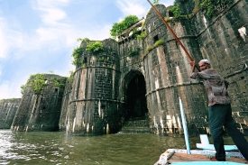
Derawar’s plan is roughly square, with high circular bastions rising from the wall line. The archaeology department describes it as about 205 metres across and reports that most of its original towers remain. A 2026 report in Dawn counted 39 bastions, while the Tentative List proposal describes 40. Because source counts differ, it is more useful for visitors to notice the repeated towers and the scale of the wall than to treat one number as definitive.
Construction materials tell another story. Dawn’s 2026 account, quoting an archaeology official, describes small fired bricks on the inner and outer faces, sun-dried bricks in the core and mud mortar as a binding material. The fort’s visible surface is therefore not a single uniform wall but a large structure assembled from materials suited to local building practices and conditions.
Architecture, neighboring monuments and conservation
The 2016 Tentative List proposal also mentions the nearby Moti, or Pearl, Mosque and the cemetery of the Nawabs of Bahawalpur, known for elaborate tombs. These places broaden a visit beyond the fortress walls, but they are distinct sites with their own access arrangements. Confirm locally which areas are open rather than assuming every monument can be entered.
Pakistan’s archaeology department lists Derawar as a protected monument under the Antiquities Act and records its ownership as private. That administrative detail is not the same as a public visiting schedule. The online government record does not publish routine hours or a standard ticket price, so travelers should obtain current access information before making the long journey.
Conservation is an active part of the fort’s present. On May 7, 2026, Dawn reported that Punjab’s archaeology department said it had completed a project costing more than 120 million rupees to restore parts of the late Nawab’s secretariat and residence, along with a nearby section of fortification wall. Officials told the paper that the renovated rooms might be opened to visitors later; the report did not confirm that they had opened.
The Urban Unit’s government master plan sets out additional proposed stages, including stabilizing the structure, restoring the outer wall and developing interpretation or visitor facilities. These are planning proposals, not confirmation that all work is funded, completed or open to the public. Conservation projects at a remote monument can proceed in phases, so current conditions may differ from a plan or a past report.
Planning a responsible visit to Derawar
Derawar lies in a desert setting, well beyond the everyday services of a large city. Official sources identify it with Cholistan and Bahawalpur, while Dawn places the fort roughly 70 kilometres from Bahawalpur. Treat that distance as a broad planning reference, not a guarantee of driving time: road conditions, route choice and weather can alter the journey.
There is no routine opening calendar or ticket information in the government archaeological record reviewed for this article. The 2026 restoration report likewise says some rooms could open in due course but does not announce public dates. Contact the Punjab archaeology department, the Cholistan Development Authority or a local tour operator before travelling, and ask specifically about access to the fort interior and the neighboring sites.
Plan transport and supplies in advance. The Cholistan Development Authority describes the region as an arid desert and explains that local communities use seasonal rainwater depressions called tobas as well as constructed water reservoirs. Visitors should carry drinking water, avoid relying on services at the monument, and check seasonal heat and road conditions before setting out. These are prudent precautions, not a claim that a particular vehicle or guide is always compulsory.
The best way to approach Derawar is to see both its commanding architecture and the limits of what is known. Its dramatic towers rise from a landscape shaped by water scarcity and caravan routes; its better-documented history is tied to the Nawabs of Bahawalpur, and its conservation continues in stages. A visit becomes richer when the fort is read not as a backdrop for legends, but as a monument whose history, access and future are still being carefully established.