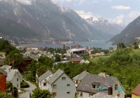
“West Norwegian Fjords – Geirangerfjord and Nærøyfjord” is the name of a serial UNESCO World Heritage property in southwestern Norway, not a single attraction with one entrance. Inscribed in 2005, it brings together two separate fjord areas about 120 kilometres apart: Geirangerfjord and Nærøyfjord. UNESCO describes a total property of 122,712 hectares, including 10,746 hectares of sea. The scale matters when planning: each area has its own villages, roads, boat services and seasonal conditions, so trying to treat both as one quick stop can mean spending the day in transit rather than experiencing the landscape.
The fjords are classic examples of valleys shaped by glaciers and later flooded by the sea. UNESCO highlights steep crystalline-rock walls, deep water, waterfalls, rivers, forests, glacial lakes and rugged mountain terrain. The high cliffs rise dramatically from the water, while hanging valleys and waterfalls show how ice and running water formed the region over long periods. This is a landscape to read slowly, from the water as well as from viewpoints and villages. The World Heritage recognition is for its natural features and geological processes; it does not mean every viewpoint or farm is a managed visitor attraction.