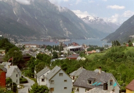
The Nærøyfjord is a fjord in Aurland, in Vestland county, western Norway. About 17 kilometres long, it is an arm of the Aurlandsfjord, which is itself an arm of the mighty Sognefjord. Reaching inland to the village of Gudvangen, it is one of the narrowest and most spectacular fjords in the world.
At its tightest point, by the hamlet of Bakka, the fjord is barely 250 metres wide, while the surrounding mountains rise as high as 1,761 metres above the sea. There the water is only about 11 metres deep over a threshold of moraine and rockfall, before the fjord widens and deepens again inland. In cold winters — as in the 1920s and in 1962 — the fjord could freeze over so completely that the scheduled boat could not get through. Small villages such as Bakka, Dyrdal and the farm of Styvi cling to its shores.