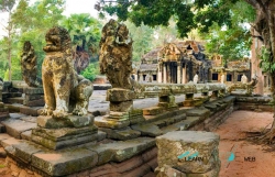
Ta Prohm is one of the best-known monuments in Cambodia’s Angkor Archaeological Park, but its setting matters as much as its image. The temple lies in a cultural landscape of former capitals, roads, reservoirs and religious sites that developed over centuries. UNESCO treats Angkor as a connected heritage area rather than a collection of isolated attractions. Approaching Ta Prohm with that wider frame helps explain why its courtyards and galleries were part of a planned urban and sacred world.
APSARA, the Cambodian authority responsible for Angkor, identifies the monument’s original name as Rajavihara, or “royal monastery.” It dates its consecration to 1186, under King Jayavarman VII, and describes a Mahayana Buddhist foundation. A 2025 account by an APSARA archaeologist says the principal image represented Prajnaparamita, the personification of wisdom, associated with the king’s mother. The detail connects the temple’s religious meaning to royal commemoration without reducing the complex to a single statue or story.