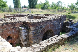
About five kilometres west of Ohrid, on the road toward Struga, the St Erasmus archaeological site is often reduced to a short biography of the Christian martyr Erasmus. That misses the place itself. The name identifies a complex beside the ancient Via Egnatia route, where an early Christian basilica and later graves were excavated below a cave church dedicated to the saint. The distinction between the church above and the archaeological remains below is important for anyone planning a visit.
The municipality’s Ohrid Region management plan lists St Erasmus as a protected archaeological site with a basilica and necropolis, dated broadly from the sixth to the twelfth centuries. The Macedonian-language encyclopedia describes the complex as a layered site rather than one building from a single moment. Its history is read through architectural remains and burials, while the religious tradition attached to Erasmus belongs to a separate strand of local memory.