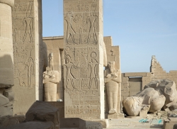
Across the Nile from modern Luxor, on the west bank among the desert hills, Deir el-Medina preserves the remains of a community whose work shaped the royal landscape of ancient Egypt. Its residents were the artisans and laborers responsible for cutting, preparing and decorating tombs in the Valley of the Kings. The settlement stood close to the royal necropolises, but its importance today reaches beyond its location: houses, tombs and an exceptional body of written evidence make it possible to study work and family life in unusual detail.
The village was established around 1500 BC, during the New Kingdom, and supported generations of craftsmen. Egypt’s Ministry of Tourism and Antiquities includes Deir el-Medina among the components of Ancient Thebes and its Necropolis, a World Heritage landscape on Luxor’s west bank. The workers were not simply anonymous laborers. Their specialized skills included stone cutting, plastering, painting and the creation of inscriptions that turned rock chambers into royal tombs.