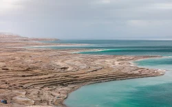
Sea of Galilee (Lake Kinneret): shore sites, trails and visitor guide
The Sea of Galilee, known locally as Lake Kinneret, is more than a single viewpoint or beach: its shoreline connects nature reserves, archaeological sites, religious destinations and working communities. A useful visit starts by choosing a section of the lake rather than trying to “see it all” in one stop. The western shore around Tiberias offers hot springs and a remarkable synagogue mosaic; on the eastern side, Kursi preserves a Byzantine monastery beside the water; above the lake, the Arbel cliffs open a dramatic panorama. Walking routes link parts of the shore, but they are not all continuously open. Check access, reservations and current notices before building an itinerary.
A lake with several names and landscapes
Lake Kinneret lies in northern Israel in the Jordan Rift Valley and is fed chiefly by the Jordan River. “Sea of Galilee” and “Lake Tiberias” are familiar English names for the same freshwater lake. Around its rim, the scenery changes quickly: Tiberias and the western slopes, open water and shoreline coves, the eastern Golan-facing shore, and the agricultural Jordan Valley at the south. This variety is why a lakeside day can combine a short walk, archaeology and a lookout rather than just a stop for photographs.
The Kinneret Circular Trail is promoted as a route of about 65 kilometres around the lake, marked in blue, purple and white. It can be approached in sections; the Israel Nature and Parks Authority’s route guide notes that some points remain closed to the public. Do not assume that the entire circuit is a continuous, unrestricted public path. For a shorter outing, the authority describes a northern section from the Capernaum-area shore toward Amun Beach, with archaeological remains, natural shoreline and viewpoints along the way. Download or review the current route map and closures before setting off.
Conditions vary between exposed waterfront stretches, paths beside vegetation and marked park trails. The authority’s hiking advice calls for enough drinking water, sun protection, suitable shoes, a charged phone and finishing before dark; it also advises against walking during extreme heat or flash-flood risk. On an unfamiliar section, use the signed trail rather than following a line on an old map. Near the lake, not every attractive inlet is an authorized bathing beach: the official Capernaum–Amun guide identifies its starting beach as unregulated and says swimming there is prohibited.
Three rewarding stops around the shore
South of Tiberias, Hamat Tiberias National Park brings together archaeology and the area’s thermal springs. Its centrepiece is a synagogue mosaic from the Mishnaic and Talmudic period, arranged with a zodiac and a central image of Helios, alongside Hebrew and Greek inscriptions. The site also preserves ancient bathing remains and a reconstructed 18th-century Turkish hammam, now presented as a museum. The combination makes the visit especially interesting for travelers curious about how religious, artistic and bathing traditions occupied the same lakeside landscape.
On the eastern shore, Kursi (Gerassa) National Park protects the substantial remains of a Byzantine monastery and church. Christian tradition identifies the area with the New Testament story known as the Miracle of the Swine; that is a tradition associated with the site, not an archaeological claim that can be independently proven. Visitors can explore the ruins and the park’s interpretation of the site, then continue along the eastern lakeshore. The authority directs drivers from the Kursi junction on Road 92, about five kilometres north of Ein Gev, to a signposted turnoff. Check the booking calendar and road conditions before travelling.
For a different perspective, Arbel National Park and Nature Reserve rises above the western side of the lake. The authority describes Arbel Cliff as 181 metres above sea level and roughly 390 metres above the Sea of Galilee, with views toward the Jordan Valley, the Golan Heights and Mount Hermon. The reserve also protects natural habitats and remains associated with an ancient Jewish settlement, synagogue, fortress and cave village. Marked walks let visitors combine the overlook with archaeology, but routes down the cliff are more demanding than a quick viewpoint stop. The last entry to cliff trails is three hours before the site closes.
Hours, tickets and getting there
As of the authority’s 2026 fee list, adult admission is ₪16 and child admission ₪7 at Kursi and Hamat Tiberias; Arbel is ₪31 for adults and ₪16 for children. Eligibility and group rates differ, so consult the full list rather than assuming these are the only prices. The parks publish seasonal opening schedules: in summer, Kursi and Hamat Tiberias list 8:00 opening and closing at 17:00 Sunday–Thursday and Saturday, or 16:00 on Fridays and holiday eves. Winter closing is listed an hour earlier. Entrance closes one hour before the posted closing time. Arbel follows a similar seasonal schedule, with its own extra cutoff for cliff routes. Verify the current date-specific schedule and reserve a time where the booking system requests it.
The three sites have separate entrances and are not interchangeable tickets. Hamat Tiberias is on Road 90 south of Tiberias; Kursi is reached from Road 92 on the eastern side; and Arbel’s official directions take drivers via the Tiberias–Golani junction and Road 7717. Search the exact English park name in the authority’s map or navigation listing, and confirm transport options locally if you are not driving. Public-transport routes and event-day arrangements can change, so an old itinerary should not be treated as a current timetable.
Plan visits to the archaeological parks in daylight and leave time for their one-hour early last-entry rule. At Arbel, a descent trail requires an even earlier arrival. For the lake itself, use only beaches currently identified as authorized for swimming and check whether lifeguards are operating; the shoreline status and seasonal services are not the same at every cove. If you prefer a low-effort day, choose one archaeological site and a nearby lakeside walk rather than combining several distant stops.
Check live conditions, then slow down
The Nature and Parks Authority’s notices page is the most useful last check for route closures, safety advisories and temporary changes. The authority has tied openings in the north to security instructions in recent notices, and closures can affect individual trails without closing an entire region. Weather matters too: heat, sudden rain and slippery ground can change the suitability of a route. Confirm the site’s own page, booking availability and local guidance on the day of travel; do not infer that a road, beach or trail is open merely because another lakeside attraction is operating.
What makes Kinneret compelling is the contrast between these experiences. At Hamat Tiberias, a detailed floor mosaic rewards a slow look; at Kursi, the remains invite reflection on how landscape, archaeology and Christian tradition overlap; at Arbel, the scale of the lake comes into view from above. The circular trail adds a way to experience the water at walking pace, while its incomplete public sections are a reminder to plan with current information. A thoughtful itinerary leaves room for the lake’s changing shore instead of treating it as a single photo stop.