Quetzaltenango (Xela): historic centre, Maya culture and highland travel
Quetzaltenango, known as Xela, is a highland city with more to offer than old buildings and access to volcano trips. At 2,333 metres above sea level, it combines a compact historic centre, K’iche’ and Maya culture, civic and cultural institutions, markets and the life of a regional capital. The city is about 200 kilometres west of Guatemala City, according to the national tourism institute’s 2026 map.
Xela, Quetzaltenango and the western highlands
The names tell part of the story. Quetzaltenango is the official Spanish name; Xelajú, from K’iche’, remains a widely used local name, and Xela is its familiar short form. INGUAT’s current tourist map notes both the city’s Indigenous heritage and a Nahuatl interpretation of the name Quetzaltenango. Rather than flattening those layers into a single origin story, visitors can recognize that the city sits within a region shaped by Indigenous languages and successive historical periods. K’iche’ and Mam are among the Maya languages associated with the wider department, while Spanish is commonly used in urban services.
At 2,333 metres, the altitude is part of the experience: mornings and evenings can feel cool even when midday is mild. The surrounding highland basin is framed by mountains and volcanoes, while the city itself has the services of a major regional centre. That mix makes Quetzaltenango useful for travelers who want both an urban stay and day trips, but it also argues for taking the first day slowly if you have just arrived from lower elevations. Pack layers, check the forecast and do not assume that a sunny afternoon means warm conditions after dark.
A walk through the historic centre
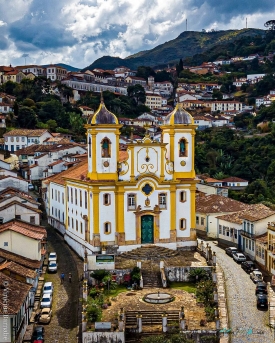
Parque Centroamérica is a natural place to orient yourself. INGUAT’s 2026 map describes the historic centre as a concentration of republican-era architecture with neoclassical influence, built in part from stone quarried locally. Around the central park, the map identifies the Cathedral of the Holy Spirit, the Municipal Palace, Casa de la Cultura, Casa Noj cultural centre, the departmental government building, Pasaje Enríquez, Palacio Figueroa and the Municipal Theatre. These are not isolated attractions in a museum compound: they sit among administrative offices, shops, cafés and everyday city traffic. Take time to look up at façades and arcades, but also notice how residents use the streets and central spaces.
The Municipal Theatre is one of Xela’s most distinctive cultural buildings. INGUAT’s visitor brochure dates its construction to 1892–1896 and notes a remodelling in 1902. The same brochure records Casa de la Cultura as an 1886 building and describes the stone Municipal Palace as the seat of the local government. These dates help visitors read the centre as a civic landscape shaped over time, rather than as a single colonial-era set piece. The theatre is also an active venue for cultural performances, but the official sources do not establish one permanent visitor schedule; check the municipal or venue announcements before planning an interior visit.
Pasaje Enríquez, opposite the park, gives the central district a different rhythm, with a covered passage linking streets and a mix of businesses and places to eat. The broader centre includes stone bridges, monuments and the Templo a Minerva, highlighted in the current tourism map. Casa Noj and other museums or cultural spaces may host exhibitions or events, but programmes change. If a door is closed, the city is still legible outdoors: the walk between the park, theatre façades and surrounding blocks is itself a way to understand Xela’s scale and architectural character.
Culture, festivals and everyday life
Quetzaltenango is often called a cultural centre of western Guatemala, and the description is visible in its institutions and public calendar. INGUAT’s map lists the Hispanic-American Floral Games in September alongside poetry, jazz and chocolate festivals, as well as museums, cultural centres and a broad food scene. These events do not run every day, and the specific programme changes from year to year. Travelers interested in a performance or festival should consult current municipal and organizer notices rather than rely on a past calendar. Even outside festival dates, the central district remains a place for local cafés, restaurants, markets and evening activity.
Xelafer, the Central American Independence Fair, is a major annual celebration in September. In 2026, Guatemala’s Ministry of Public Health reported on food-safety inspections during the fair, confirming its large public and commercial footprint. That report is useful as evidence of the event’s scale, not a future schedule: dates, street closures, attractions and transport arrangements can change each year. If you plan to visit during the fair, expect a busier city and check official notices for the current edition. The theatre, Parque Centroamérica and other civic spaces can host performances or public activities, but availability depends on that year’s programme.
Practical planning for a city visit
The historic centre is best explored on foot, with local transport or taxis for longer trips and neighbourhoods beyond the central grid. Road travel links Quetzaltenango with Guatemala City and other western highland destinations; the national tourism institute’s 2026 guide and map are useful for getting oriented, while actual bus services and road conditions should be confirmed close to departure. A regional airport is listed for the city, but flight operations can vary; do not build an itinerary around a flight without checking directly with the airline or airport operator.
There is no single ticket or opening time for the historic centre. Streets and public spaces can be enjoyed independently, while the theatre, museums, churches and cultural institutions each set their own access rules and hours. The INGUAT Tourist Information Office in Quetzaltenango says it assists national and international visitors in Spanish and English with attractions, transport, food and registered tourism services. Its listed address is Avenida 1-17, Zone 4, Civic Centre. The office page does not publish a dependable daily opening schedule, so contact it or check the current listing before making a special trip.
For a first day, keep the plan simple: walk Parque Centroamérica and its surrounding civic buildings, check whether the Municipal Theatre or a cultural centre has a public event, then choose a meal in the centre. The next day can be for a nearby destination. INGUAT identifies Fuentes Georginas near Zunil, the volcanic landscape and the historic centre among regional attractions; these excursions lie outside the city and require separate transport planning. Ask a current local operator about road, weather and trail conditions, especially for mountain activities, instead of treating old travel times as guarantees.
A highland city worth more than a quick stop
Quetzaltenango rewards visitors who balance monuments with ordinary city life. The architecture around Parque Centroamérica offers a visible thread through the city’s civic history, while K’iche’ heritage, cultural venues, markets and food make clear that Xela is not a preserved set. Its altitude and regional connections also make it a practical base for exploring the western highlands, provided that excursions are checked individually. Use the 2026 INGUAT map to choose a first walking route, verify current schedules for indoor venues and leave room for the unplanned discoveries between landmarks. That is where the city’s character becomes more than a list of sights.