Cartagena de Indias: a Caribbean port shaped by walls and exchange
A port city whose geography became its story
Cartagena de Indias faces the Caribbean from a sheltered bay on Colombia’s northern coast. The water, channels and narrow approaches influenced the city’s role as a harbour and later shaped its defenses. The UNESCO-listed property is not just a postcard of bright façades: it includes the port, fortresses and a historic urban ensemble whose streets and public spaces grew from centuries of maritime exchange, conflict and community life.
UNESCO records the city’s colonial foundation in 1533 and describes Cartagena as one of the most important ports in the Caribbean. Its position connected maritime routes with inland parts of New Granada. For centuries, ships, officials, merchants, soldiers, craftspeople and enslaved Africans passed through this port city. A responsible account of Cartagena’s beauty must also recognize that its wealth and imperial importance were tied to coercion and the forced movement of people.
The city’s walls emerged over a long period rather than from one unified building campaign. UNESCO describes fortifications begun in the late sixteenth century and strengthened through the eighteenth, adapted to the bay’s inlets and passages. Bastions and castles guarded different approaches to the harbour and city. Their scale helps visitors understand why Cartagena was contested by European powers, but the masonry also reflects the labour and political system that produced it.
Three historic districts, many ways to read the city
Within the protected centre, UNESCO identifies three historic sectors: Centro, San Diego and Getsemaní. Centro includes the cathedral, religious institutions, government buildings and residences associated with colonial elites. San Diego developed as a district of merchants and artisans, while Getsemaní grew as a popular quarter beyond the earliest central core. The distinctions are historical, not boundaries that prevent visitors from walking between them.
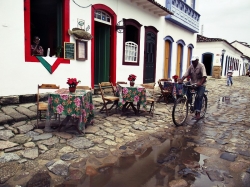
In Centro, narrow streets open into plazas and reveal houses whose balconies and courtyards face inward as well as outward. Colombia’s official tourism portal recommends exploring the historic centre on foot and points to its squares, museums, churches and colonial architecture. Walking is useful not only for reaching attractions but also for noticing how shade, stone, doors and street-level businesses shape daily experience in a dense tropical city.
Getsemaní offers a different urban texture, with public gathering places and streets that connect the old core to the wider city. It should not be reduced to a backdrop for photographs: people live and work here, and its history includes communities whose labour supported the port and its construction. Visit with consideration, avoid blocking narrow lanes, ask before photographing people at close range, and remember that local neighbourhood life continues after visitors leave.
Fortifications as architecture and as historical evidence
The fortifications form a network, not a single wall that can be understood from one viewpoint. UNESCO lists the urban enclosure, harbour defenses and castles positioned around key passes, including the prominent Castillo San Felipe de Barajas on a rocky rise east of the centre. The system responded to the geography of bays, channels and land approaches. From a visitor’s perspective, the elevated fort and the walled centre make most sense when considered together.
Colombia’s official tourism material traces the walls’ construction across generations and explains their defensive purpose. The UNESCO description adds the larger regional context: Cartagena, Havana and San Juan formed essential links in the Spanish Caribbean route. That history connects local streets to a wider Atlantic world of shipping, military rivalry and colonial rule. It also calls for careful interpretation rather than romanticizing a fortress as a neutral symbol of adventure.
The historic property is protected through Colombian heritage measures, and UNESCO notes that interventions affecting the protected site require authorization under national law. For visitors, this is a reminder that old buildings are not props. Keep to signed routes, do not climb on restricted masonry, and follow the rules of museums and fortifications. Conservation is especially important in a coastal environment where weather, use and urban change all place pressure on historic fabric.
Plan a visit around what can be confirmed
The old centre rewards a slower itinerary. Start with a walk through Centro, then cross into San Diego and continue to Getsemaní, leaving time for a museum or church whose opening is confirmed for your date. The walled streets and public squares are visible parts of the city, but individual interiors and fortifications may have separate tickets, entry controls or temporary closures. Check the official site of each attraction rather than assuming that one pass covers everything.
Colombia’s tourism portal describes the historic centre as a place to explore on foot and highlights the layered architecture and public spaces. Comfortable shoes, water and breaks in shaded places make a walking day easier. The city is large beyond its historic core, so do not assume every beach, island or modern district is a short stroll away. For excursions beyond the centre, check transport, access and current conditions with an established operator.
Opening hours, ticket prices and local services can change, and the sources reviewed for this article do not establish one universal schedule for the entire heritage property. Before setting out, confirm museum and castle access, transport arrangements and any local notices. Cartagena is most rewarding when its beauty is read alongside its layered history: a Caribbean port, a fortified colonial city, a place marked by forced migration and a living urban community—not simply a collection of colourful backdrops.