About Huancayo
A highland capital in the Mantaro Valley
Huancayo is the capital of Peru’s Junín department and province, set in the Mantaro Valley of the central Andes. It is a working regional city, not a single attraction with one entrance or opening time. The official PROMPERÚ guide places the city at about 3,259 metres above sea level, a detail worth considering when planning the first day. The historic centre makes a useful starting point: Constitution Square and Huamanmarca Square sit within the monumental zone, while the Wanka Identity Park and the eroded towers of Torre Torre introduce the region’s cultural and natural landscapes.
Getting there is part of the scale of the trip. PROMPERÚ’s 2026 guide gives the road distance from Lima as about 298 kilometres and estimates seven hours by land, while noting flights to Jauja take about 30 minutes. Jauja is a separate city; the guide places it roughly 46 kilometres, or about an hour by road, from Huancayo. These are planning estimates, not guaranteed travel times. Check current flight availability, road conditions and bus departures before booking, especially if your itinerary depends on a same-day connection.
Constitution Square and a layered civic history
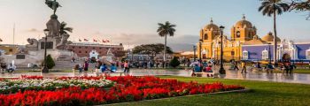
Plaza Constitución is among Huancayo’s best-known central spaces. Peru’s tourism inventory traces it to the late eighteenth century, when it was called Plaza del Comercio. The name changed in 1813 after the Constitution of Cádiz was sworn there. The episode connects a local square to the political changes of the Spanish-American period, but its story did not stop with that ceremony: the inventory also records later constitutional and republican events, as well as successive changes to the square’s design.
The surrounding space has been remodelled over time as Huancayo expanded. The tourism inventory notes early twentieth-century street paving and a central paved area installed in 1909, followed by mid-century enlargement and monuments. Today, trees, planted beds and civic monuments make it a place to pause and orient yourself in the centre. The same inventory places it at about 3,251 metres above sea level and records thousands of local and national visitors during four Saturdays in October 2024. Those counts are a dated sample, not an annual total, but they show that the square is part of everyday city life as well as a heritage stop.
Huamanmarca: the city’s older point of reference
A short walk links Constitution Square with Plaza Huamanmarca. The tourism ministry’s inventory describes the site as having a pre-Hispanic history and says historical and archaeological research associates it with worship by the Huamanmarca ayllu. It separately identifies an oral tradition, recorded by early chroniclers, about a spring emerging beside a sacred rock. Keeping those accounts distinct matters: the first is presented as research, while the spring story is a transmitted tradition, not a physical feature a visitor should expect to see today.
The same inventory records the Spanish foundation of Huancayo at this location in 1572, under the name Santísima Trinidad de Huancayo. A church begun in 1580 was completed in 1619 and later destroyed by an earthquake in 1772. The square also has a republican and commercial history: it became a market area in the late nineteenth century, and the inventory recalls executions during the War of the Pacific commemorated by statues. Its present-day civic design includes benches, planting, water features and an information kiosk. Taken together, the two central squares make a compact walk through different periods rather than a single, simplified origin story.
Wanka Identity Park: popular art in an urban setting
For a different view of local identity, travel to Parque de la Identidad Wanka in the San Carlos area. PROMPERÚ’s 2026 guide places the park about five kilometres northeast of central Huancayo, around ten minutes by car; the MINCETUR inventory identifies it among the streets of the San Carlos neighbourhood. Its 5,800-square-metre grounds were built between 1992 and 1996. Rather than reproduce one archaeological site, the design translates regional craft and visual references into an urban landscape of curves, stonework, paths and sculptures.
The park’s details reward a slower walk. The tourism inventory describes walls and paving that evoke traditional stone construction, materials including marble, quartz and coloured slabs, and planted areas with native and regional species. A carved gourd more than two metres high welcomes visitors, according to PROMPERÚ; the park also includes figures and spaces that interpret Wanka popular culture. These features make it a place for a walk, photographs and a first introduction to local art, not a substitute for a museum collection. The official records do not provide a current ticket price or guaranteed daily opening schedule, so check locally before making a special trip.
Torre Torre and the landscape shaped by erosion
East of the city, Torre Torre offers a striking change from the urban squares. The MINCETUR inventory describes clay-rich sedimentary columns carved by wind and rain, some rising to around 30 metres. More resistant material at the top protects weaker layers below, producing the tall, hoodoo-like forms that gave the area its name. The formations occupy a ravine landscape rather than a built attraction: erosion remains active, and the surrounding ground includes loose deposits and sparse vegetation. Stay on established paths and avoid climbing or touching fragile columns.
The official inventory gives Torre Torre an elevation of about 3,413 metres and describes an approach from Constitution Square by private car: 3.4 kilometres to the Bicentennial Cultural Park, followed by about one kilometre on an unpaved road. Its route table estimates 20 minutes for the first leg and 10 minutes for the second, but road and weather conditions can change. The site is municipally protected as a natural geological area and tourist attraction under a 2006 ordinance. MINCETUR recorded visitors on Sundays in September 2024, but its listing does not establish a current entrance fee or daily hours.
Food, timing and a practical city visit
Huancayo also works as a base for regional food and craft. PROMPERÚ’s Junín guide highlights dishes such as patachi, a wheat-and-bean soup; yaku chupe with potato, cheese and herbs; and carnero al palo, roasted mutton. These are regional examples rather than a promise that every restaurant serves them daily. The guide’s calendar lists the Festival of Santiago in Huancayo and neighbouring Mantaro Valley towns in July and August, and a Mantaro Valley tourism week in November. Event programmes change; confirm dates with the local tourism office before arranging travel around a festival.
For a first visit, pair the two central squares with the Wanka Identity Park, then set aside a separate trip for Torre Torre. The official guide suggests a multi-day Mantaro Valley itinerary, which is more realistic than trying to cover every nearby town in one day. The plazas are listed as cultural resources without a published ticket price in the records consulted; the park’s schedule is likewise not confirmed there. At more than 3,200 metres, leave room to adjust your pace after arriving, and check transport and weather close to departure. Huancayo’s appeal lies in the way civic history, Wanka art and an eroded Andean landscape meet within reach of a lively regional capital.