About Duggleby Howe
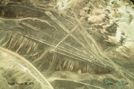
Duggleby Howe (also known as Howe Hill, Duggleby) is one of the largest round barrows in Britain, located on the southern side of the Great Wold Valley in the district of Ryedale, and is one of four such monuments in this area, known collectively as the Great barrows of East Yorkshire. Duggleby Howe is believed on the basis of artefacts recovered to be of Late Neolithic date, but no radiocarbon dates are available. Howe as a place name is believed to have originated from the Old Norse word haugr. The monument consists of a mound, the base of which was 120 feet (37 m) in diameter. The top of the barrow was apparently truncated at some point in the past, leaving an almost-level platform some 47 feet (14 m) in diameter. On this was constructed a post-mill of medieval type. The mound was 22 feet (7 m) high at the eastern end and 18 or 19 feet (5.8 m) (5 or 6 metres) high at the western end. The barrow lies within a roughly circular enclosure, approximately 370 metres in diameter, formed from interrupted ditches, and open to the south. To the east of the barrow, one within the enclosure and one outside, are two ring ditches, believed to be of Bronze Age date. Although the barrow itself was long known, it was not until 1979 that the existence of the enclosure was confirmed using aerial photographs taken by D.N. Riley. The barrow was first excavated in either 1798 or 1799 by the Reverend Christopher Sykes, but of his excavation no records remain. Beginning on 21 July 1890 J.R. Mortimer, under the sponsorship of Sir Tatton Sykes, excavated "an area of 40 feet square over the centre of the barrow, and a portion of the east side" over a period of more than six weeks. This excavation was re-assessed by Ian Kinnes, Timothy Schadla-Hall, Paul Chadwick and Philip Dean in 1983 to produce the interpretation presented below.