Hatra, Iraq: inside the Parthian city that resisted Rome
A city built to command a crossroads
In the semi-desert of northern Iraq, Hatra’s circular outline still reads as a statement of power. The ancient city stands about 110 kilometres southwest of Mosul, on routes that connected Mesopotamia with the lands farther west. UNESCO describes it as a major fortified settlement and religious centre in the Parthian sphere. Its significance is not only the survival of stone walls: Hatra preserves evidence of a society positioned between empires, languages and artistic traditions.
The settlement grew from a smaller community into a regional centre during the first centuries before and after the start of the Common Era. Its location helped it serve as a commercial and political outpost between Roman territory and the Parthian kingdom. Hatra’s rulers were locally powerful, while the city’s prosperity depended on movement across the wider region. That position made it strategically valuable—and exposed it to repeated pressure from Rome.
Hatra is often remembered for resisting Roman campaigns. UNESCO records that the city withstood attacks associated with Trajan in 116 CE and Septimius Severus in 198 CE. Those victories helped make it a symbol of Parthian power. The city later fell to the Sasanian forces around 240–241 CE. Its story is therefore not a simple tale of an impregnable fortress: it is a record of changing alliances, military technology and the shifting balance of power in late antiquity.
Reading the walls and the sacred centre
The urban plan is unusually legible from above. A broad outer defensive circuit surrounds a more compact stone wall, with gates, towers and a moat forming successive layers of protection. UNESCO describes the inner enclosure as roughly two kilometres across and the surrounding outer wall as about nine kilometres in circumference. These figures help explain the scale, but the experience of Hatra comes from seeing how the defensive system relates to the plain around it.
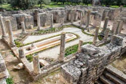
At the centre lies the temenos, a rectangular sacred precinct that gathered temples and other religious buildings. Its monumental iwans—vaulted halls open at one end—show how local builders combined eastern construction traditions with Hellenistic and Roman forms. Stone carving, sculpture, inscriptions and architectural details make the site more than a military landmark. The buildings reveal how rulers used religious patronage to express authority and how communities shaped a distinctive visual language.
Hatra’s inscriptions are especially valuable because they preserve Hatran Aramaic, a local form of Aramaic used in the kingdom. Sculptures and dedications point to a religious world in which different traditions met rather than a single uniform cult. UNESCO describes the cultural fabric as shaped by Assyro-Babylonian, Aramean, Greek, Parthian, Roman and Arab influences. This mixture should not be mistaken for a modern melting-pot slogan; it is visible in the surviving evidence of a city tied to many networks.
The semi-desert setting is part of the heritage, not empty background. UNESCO notes that roads, bridges, wells and other archaeological remains in the surrounding landscape help explain Hatra’s reach and its role as a fortified outpost. Looking only at the central temples would miss the system that sustained the city: access to water, routes through the steppe and the relationship between the settlement and its defensive perimeter. The wider archaeological landscape also needs protection.
Archaeology, conflict and conservation
Modern archaeological work has documented Hatra over many decades, and earlier excavations exposed much of the monumental core. Some rooms in the temenos were used as a local museum, while conservation campaigns restored walls and buildings. UNESCO cautions that much of the architecture was already ruinous when excavated. The visible remains therefore represent both ancient construction and later archaeological choices about how to stabilize and present a vulnerable site.
The city suffered localized damage during the conflict of 2015–2017, including harm to architectural decoration. UNESCO also identifies neglect, looting and severe weathering as continuing risks. The danger listing is not a measure of Hatra’s cultural importance; it is an international warning that the property remains vulnerable and requires sustained safeguarding. Visitors should understand that conservation is an ongoing process, not a completed project that can be judged from a single photograph.
In August 2026, Iraq’s National News Agency reported an announcement by the State Board of Antiquities and Heritage concerning a first phase of cooperation to clear debris and begin rehabilitation preparations, with Italian and local partners. The report described later work as dependent on studies, designs and funding. That distinction matters: an announced first phase does not mean that restoration is complete, that every area is safe, or that a regular visitor service has begun.
Hatra’s history also shows why the site deserves care beyond its postcard image. Its remains are archaeological evidence, a record of local craftsmanship and part of the living cultural inheritance of Iraq. Do not climb on masonry, handle fragments or remove objects. Where access is authorized, follow staff instructions and barriers. The same caution applies to photography: documentation should never take priority over protected surfaces, archaeological work or the safety of people on site.
Planning responsibly around access
Hatra is remote, and the public sources reviewed for this article do not establish a dependable daily opening timetable, ticket price or routine tourist transport. UNESCO says the Iraqi State Board of Antiquities and Heritage manages the property and that site activities require its approval. Before making plans, contact the responsible Iraqi heritage authorities or a licensed local operator to confirm whether access is permitted, what route is safe and whether a guide or escort is required. Do not assume that a map pin guarantees entry.
The distance from Mosul is useful for understanding the geography, not a promise of travel time. Road conditions, security guidance and authorized access can change, so check current local information close to the intended date. Avoid travelling independently into a remote archaeological zone without confirmed arrangements. If access is not available, the UNESCO record and archaeological collections and interpretation at Iraqi museums offer safer ways to learn about Hatra’s place in regional history.
For readers interested in the site, a rewarding visit begins with context rather than a checklist. Study the circular defenses, then follow the line inward toward the temples and the open halls. Notice the contrast between monumental stone architecture and the wide steppe beyond the walls. Where a guide is authorized, ask how inscriptions, building phases and conservation decisions are distinguished from later reconstruction; careful interpretation is more valuable than repeating legends as established fact.
Hatra remains compelling because it turns a difficult historical question into a visible landscape: how did a city on the edge of two empires protect its autonomy and build a lasting identity? Its walls, sanctuary and inscriptions offer part of the answer, while the exposed setting and present conservation risks remind visitors that heritage is never guaranteed. If you can visit only with official permission and current local guidance, that restraint is part of responsible travel—and part of respecting the site itself.