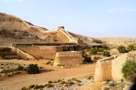
At Kot Diji in Pakistan’s Khairpur district, a long masonry fort follows the crest of a limestone ridge. Its elevated position makes the logic of the building clear even before its gates come into view: the rulers of Khairpur wanted to watch and defend the approaches to their capital. The Sindh Directorate of Antiquities identifies Mir Sohrab Khan Talpur as the ruler who founded this and two other forts to protect the frontiers of his state. The fort belongs to the late eighteenth-century Talpur period, although official descriptions differ on the precise construction year. It is a monument to regional power, not a surviving wall from the Indus civilisation.
The distinction matters because Kot Diji has another, much older archaeological story. A prehistoric mound nearby yielded material that gave its name to a phase of early Indus archaeology. The mound and the fort share a place-name, but they are separate sites, separated by millennia and by purpose. A traveller reading an old account can easily leave with the impression that Talpur soldiers stood behind prehistoric ramparts. They did not. The fort rises from an era of princely politics and gunpowder defence; the mound belongs to the long development of settlements before the mature Indus cities.