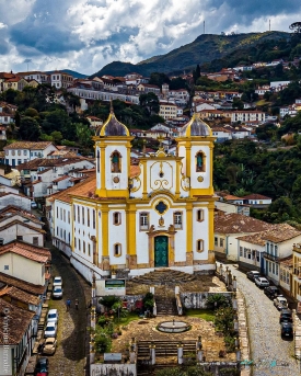
Diamantina stands in the rocky highlands of northeastern Minas Gerais, where its historic streets climb and descend along a steep valley rather than following a level grid. UNESCO describes the centre as rising about 150 metres up the slope, with winding, uneven routes that reflect the terrain. That relationship between town and landscape is central to the visit: the view changes as streets bend, and houses, churches and public spaces appear in layers against the surrounding mountains. The result is not a stage set of isolated monuments but an urban fabric shaped by adaptation to a demanding environment.
The settlement was first known as Arraial do Tijuco and grew during the colonial period as diamonds were found and mined in the region. Its name, Diamantina, preserves that association with precious stones. The historic centre entered UNESCO’s World Heritage List in 1999. The recognition is not based only on the town’s mining past: UNESCO emphasizes how Portuguese architectural models were adapted to an American setting and how the built environment was integrated into the rocky hills. A visit becomes more rewarding when the street plan is read alongside the history of prospectors, colonial administration and local cultural life.