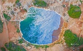
Corta Atalaya is an immense open-pit excavation at Minas de Riotinto in Huelva, Andalusia. Its stepped walls and elongated, almost elliptical outline make the mine legible from a viewpoint: this is not a natural crater but a landform made by generations of industrial extraction. A heritage dossier published by the Andalusian regional government records that open-pit work began here in 1907 and documents a major axis of about 1,234 metres, a minor axis of 954 metres and a depth of 335 metres. Those measurements describe the historic excavation in the official record; they should not be confused with a current survey or with a claim that all of the pit is accessible to visitors.
The site belongs to the much wider Riotinto-Nerva mining basin, whose mineral resources and changing techniques shaped the landscape over thousands of years. The Junta’s heritage description notes archaeological evidence for mining in the region from roughly five millennia ago, Roman extraction and later large-scale industrial development. These are histories of the basin, not a suggestion that the modern Corta itself has been continuously mined for five thousand years. The distinction matters: the visitor sees one dramatic feature within a layered cultural landscape that also includes railway infrastructure, processing works, worker settlements and archaeological remains.