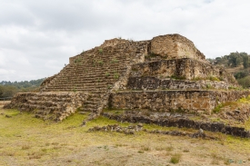
Cerro de la Minas is an archaeological site located in the modern state of Oaxaca, just to the north of the city of Huajuapan de León. The site belongs to what is called the Ñuiñe, or lowland/hot lands Mixtec cultural area. The site is located on a hill that dominates the Valley of Huajuapan, in what are now the neighborhoods of Chapultepec, Santa Rosa, Alta Vista and Del Maestro of the city. This large hill is in a strategic position over the farmlands of the valley, which provided it with its food, as well as the trade routes that cross this valley, which made it regionally important. The site contains a number of settlements and was reserved for the elite of that area during that time. Cerro de las Minas is the only lowland Mixtec archeological site open to the public.