About Safranbolu
Safranbolu is a historical and touristic district of Karabuk province. Its location is 231 km north of Ankara and 90 km south of the Black Sea. It is located 8 km north of the town center of Karabuk. Safranbolu city center and Karabuk city center are adjacent to each other.
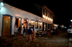
Famous for its historical Safranbolu houses, which reflect the Classical Ottoman urban architecture, examples of which can be found in many parts of Turkey such as Beypazarı, Göynük, Taraklı, Odunpazarı and Osmaneli, the city has been on the World Heritage List in Turkey since 17 December 1994. It is one of 9 cultural assets and attracts touristic interest. Safranbolu takes its name from saffron, a rare plant that grows in the region.
Due to its geographical location, Safranbolu has been an administrative and commercial center throughout history. According to the 2010 address-based census, its population is 49,014.
It is located in the region called Paphlagonia in the Roman Empire and has hosted many civilizations. It was definitely taken by the Turks in 1196. It lived its most important period in history because it was on the Istanbul-Sinop road in the 17th century during the Ottoman period.
The city is located in the Paphlagonia region, which is mentioned in Homer's Iliad epic in ancient times, and its known history goes back to 3000 BC. The tumuli of 3000 and 4000 BC show that Safranbolu has a long history in terms of human settlement. The city has been interpreted with ancient towns such as Flaviopolis, Theodoropolis, Hadrianopolis, Germia and Dadibra (Dadybra). The first known civilizations in the region are the Gaspas and Zalpas, neighbors of the Hittites. Hittites, Phrygians, indirectly Lydians, Persians, Hellenistic Kingdoms (Ponds), Romans (Byzantine), Seljuks, Çobanoğulları, Candaroğulları and Ottomans dominated the region, respectively.
When the city was conquered by the Seljuks, its name was Dadibra. Safranbolu, Seljuk Sultan II. It was captured by the Turks in 1196 by Muhiddin Mesut Shah, son of Kılıç Arslan. Muhiddin Mesut Shah promised the Greek-Byzantine population that he would protect their lives if they surrendered without a fight, but according to the records, the city was captured by war. There is no information about what happened to the Christians. It was in the hands of the Çobanoğulları Principality between 1213-1280, the Candaroğulları Principality between 1326-1354 and the Ottoman Empire after 1423. In the current Kıranköy area, there was a Greek community. This place later became the central Greek quarter and the population change in 1923 took place in this region.
Under the rule of the Seljuks, the name of the city was Zalifre and it became the end region of Sinop - Kastamonu - Safranbolu - Gerede - Söğüt. In the following years, the city changed hands several times between the Turkmens and the Byzantines. Between 1213 and 1280, the town was ruled by the Çobanoğulları Principality, which settled in the Kastamonu and Sinop regions, which were the border principalities of the Anatolian Seljuk State. Later, the Shepherds began to pay taxes to the Mongol Ilkhanate.