About Milford Sound
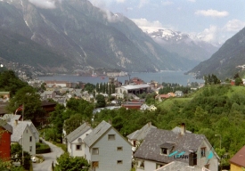
Milford Sound / Piopiotahi is the dramatic endpoint of one of New Zealand’s most memorable road journeys. The inlet lies in Fiordland National Park on the South Island, where steep, glacier-cut walls rise from dark water and waterfalls descend from forested cliffs. The English word “sound” is a historical label: geologically, this is a fiord carved by ice and later flooded by the sea. Its Māori name, Piopiotahi, means “one piopio,” referring to a native thrush now thought to be extinct.
A landscape formed by ice and rain
From the settlement at Milford, the fiord extends about 16 kilometres toward the Tasman Sea and reaches depths of roughly 265 metres in places, according to New Zealand’s Department of Conservation (DOC). Mitre Peak—Rahotū in Māori—rises sharply above the water, while Bowen and Stirling falls are among the landmarks visible from the fiord. The surrounding rock walls record repeated glaciation: ice carved deep U-shaped valleys, and the sea later entered them. Milford is part of Te Wāhipounamu, the UNESCO-listed Southwest New Zealand World Heritage Area, whose value includes its glacial landforms, rainforests, alpine environments and largely intact ecosystems.
Rain is not an interruption to the scenery here; it helps make it. DOC describes the region as exceptionally wet, and heavy rainfall feeds both permanent and temporary waterfalls. A layer of fresh water can sit above the darker seawater, reducing light below the surface. Researchers call the resulting ecological effect “deep-water emergence”: species normally associated with greater depths can occur unusually close to the surface. Piopiotahi Marine Reserve, established in 1993, protects a 16-kilometre section along the fiord’s northern side. Its underwater walls support sponges, soft corals, sea squirts and black coral; seals and occasional bottlenose dolphins also use these waters. A standard boat trip offers views of the landscape, but sightings of particular wildlife are never guaranteed.
A Māori route and a name with a story
Piopiotahi’s cultural history reaches beyond the modern road. DOC records that early Māori used a sea route along the Fiordland coast to carry pounamu, or greenstone, toward Murihiku in the south. An inland route followed what is now the Milford Track and connected the coast with Lake Te Anau. Permanent Māori settlements were located in the Hollyford Valley and around Lakes Manapouri and Te Anau, where food and forest resources supported travel and community life.
The name Piopiotahi refers to the piopio, a native thrush now believed extinct. Te Ara, the New Zealand encyclopedia, also recounts a Māori tradition in which the bird’s journey south is associated with the hero Māui. This account is one strand of local storytelling, not a substitute for the many histories and relationships Māori hold with the wider Fiordland region. Using both names—Milford Sound and Piopiotahi—recognizes the different histories embedded in the landscape.
Getting there: the road is part of the visit
Milford Road, State Highway 94, begins at Te Anau and runs about 120 kilometres to the fiord. DOC estimates around two hours to drive it without stops, but the route has viewpoints and short walks that reward extra time. A day that includes scenic stops and a boat cruise can take about eight hours. The nearest town with a full range of services is Te Anau; facilities at Milford itself are limited. Mobile coverage is also limited along much of the corridor, so download maps and key booking information before leaving.
Conditions can change quickly. Rain, rockfall, snow and avalanche risk may cause delays or closures, particularly in winter. Before departure, check the current SH94 status with NZ Transport Agency Waka Kotahi and DOC’s Milford Road advice. DOC advises drivers to fuel up in Te Anau, allow at least two hours for the drive to a booked cruise, and leave about 45 minutes to park and walk to the terminal. Parking is limited and can fill quickly in peak periods. Guided coaches are an alternative for travelers who do not want to manage a long, demanding drive.
Cruises, crowds and practical expectations
Boat cruises are the most direct way to experience the fiord from water level. Operators run on schedules that vary by season and company, so compare current departure times and booking conditions rather than assuming a boat is available on arrival. There is no single “opening time” for the natural fiord itself; visitor services, parking and cruises each have their own operating arrangements. DOC’s February 2026 visitor notice described a particularly busy summer: December day-cruise passenger numbers were up by 12,117, or 13 percent, and overall visitation was reported 6 percent above the pre-COVID peak. Those figures describe a dated period, but they underline why planning ahead matters.
Facilities are deliberately limited in this remote World Heritage setting. Take rubbish out with you, use available toilets and follow staff instructions. Drones are prohibited on conservation land without a permit. The marine reserve protects sensitive habitats, so do not collect marine life or disturb wildlife. Rain gear and layers are sensible even when the sky looks clear in Te Anau; conditions at the coast may be very different.
Make the journey part of the story
Milford is often marketed as a single spectacular viewpoint, yet the drive through Fiordland reveals why this is a protected landscape rather than merely a backdrop. Forest, glacial valleys, alpine passes and the fjord itself form a connected sequence. Travelers who leave time for the route, check conditions, and approach the water with realistic expectations are better prepared to appreciate both the scale and fragility of Piopiotahi.
For a responsible visit, confirm the road status, cruise booking and parking plan close to departure; carry food, water and warm waterproof clothing; and avoid relying on mobile reception. The fiord is beautiful in both rain and sunshine, but weather, road access and marine conditions are part of the experience. Respecting those limits helps protect the place that makes the journey worth taking.